36.005271, -78.896742
Cross Street
Year built
1920-1930
Architectural style
National Register
Neighborhood
Building Type
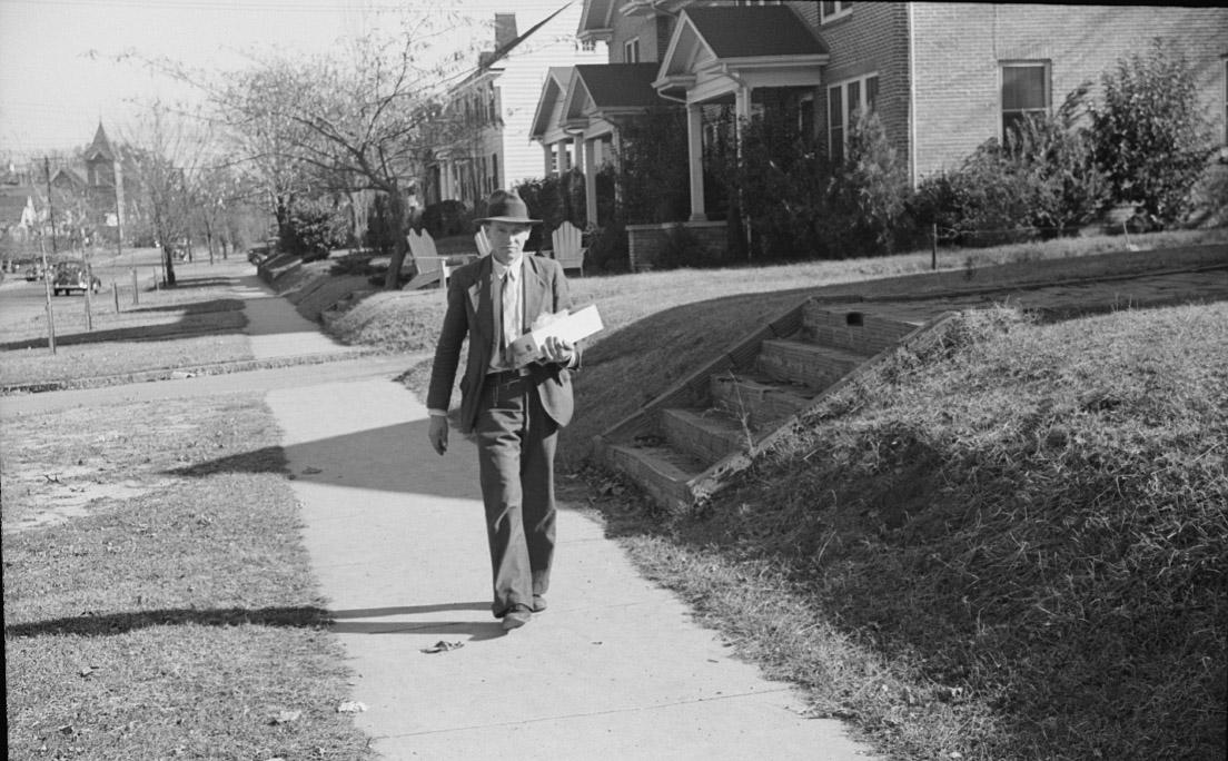
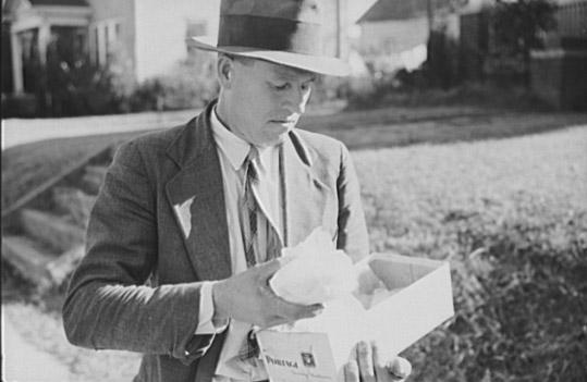
"Mr. Evan Wilkins with butter he is selling which was made on his farm. Durham, North Carolina"
November 1939
(Courtesy Library of Congress)
Solution:
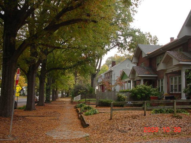
West Trinity and Bay Street - looking east. Thanks to Peter for taking a present-day shot:
Comments
Submitted by Anonymous (not verified) on Thu, 10/29/2009 - 3:21pm
Are those the apartments on Geer St on the right?
Submitted by Steve (not verified) on Thu, 10/29/2009 - 3:40pm
and perhaps a church in the left background?
Submitted by Michael Bacon (not verified) on Thu, 10/29/2009 - 3:47pm
I think those buildings still exist. Trinity Ave., Old North Durham, looking east.
Google maps view.
Submitted by Michael Bacon (not verified) on Thu, 10/29/2009 - 3:49pm
That would mean the church in the background is likely some previous incarnation of the Grace Baptist Church on Mangum.
Submitted by Batman (not verified) on Thu, 10/29/2009 - 4:01pm
I think the church is Calvary Methodist Church, 304 E Trinity Ave. View is to the west on East Trinity. My grandmother attended for over 50 years.
Am I right?
Submitted by Michael Bacon (not verified) on Thu, 10/29/2009 - 8:05pm
The shadows are wrong for it to be looking east, unless the photos are flipped, and the writing on the box makes it look right. Anyway, the shadows go to the left across the picture, which either means this is looking east (south is to the right) around noontime, looking north in the early morning, or looking south in the late evening. The shadow lengths would be right for coming from the south at around noon for early January.
Mainly, though, I don't know of any other road in an old part of Durham that's this residential and has this much buffer between the sidewalk and road. Trinity is pretty unique in that regard.
Submitted by Anonymous (not verified) on Thu, 10/29/2009 - 9:16pm
Re: first Anon post. I followed the current street map on Geer. I didn't think that the church could be seen from those apts. on Trinity, but it looks more plausible than Geer.
Trinity gets my vote now.
Submitted by Keith (not verified) on Thu, 10/29/2009 - 9:34pm
From one of Gary's old posts I thought I remember him including a picture and information about a church associated with the school (not the one there now) that used to sit at the corner of North and Geer?
The apartment buildings in the foreground sure look like the ones on Geer St. as you head east towards Mangum.
Submitted by Michael Bacon (not verified) on Fri, 10/30/2009 - 1:31am
Check out the Google maps view I linked to. The apartment building on Trinity has the same front.
Submitted by Michael (not verified) on Fri, 10/30/2009 - 1:41am
You can see the road to the park next to the apt in the pic and on the google link.....The roofline is also correct on the next house....
Submitted by Gary (not verified) on Fri, 10/30/2009 - 2:58am
Yep - I think we have a winner with West Trinity near Bay St., looking east. Michael, I'm going to need to give you a prize soon.
GK
Submitted by Steve Graff (not verified) on Fri, 10/30/2009 - 5:32pm
I love these mystery photos! Michael is spot on! It is the four unit building on W. Trinity Ave. at Bay St. The elevations and buffers between the street and sidewalk all match.
The church in the distance must be a previous iteration of Grace Baptist, which according to their web site was re-built beginning in 1948. Calvary UMC is too far away to be the church shown in the photo.
Submitted by Anonymous (not verified) on Fri, 10/30/2009 - 6:31pm
Interesting how the yards have been leveled off since the pictures were taken.
Submitted by Anonymous (not verified) on Sat, 10/31/2009 - 11:36am
Cool your boots everyone, anon has a good point about the yards being leveled off - there are clearly young trees planted in the historic photo, and in the modern photo, the street level and right of way (with mature trees) is significantly higher... I don't see how the ground and street could have grown up with the trees... Could this possibly be somewhere else that looks very similar to E. Trinity? The buildings look like a pretty common building type...
Submitted by Gary (not verified) on Sat, 10/31/2009 - 12:02pm
I don't have an explanation for what was done to the yards or street to change the grade, but the pattern of buildings matches exactly - as does the unique width of the street buffer. See the present day photo I've added.
GK
Submitted by G Wolf (not verified) on Sat, 10/31/2009 - 3:40pm
There are still steps leading up to the houses. It just looks like some of the ground in front of the houses was brought down a bit, rather than the street level being raised up. I think that is a more plausible scenario than raising the entire street.
One question though: in the current photo, there's a street sign for a rotary (traffic circle, whatever) coming up. I'm guessing that was added to the intersection some time after 1939?
Submitted by Steve Graff (not verified) on Sun, 11/1/2009 - 12:43pm
The traffic circle is new - installed only about four years ago.
Submitted by Steve Graff (not verified) on Sun, 11/1/2009 - 1:03pm
The elevation still exists on the west side of Bay Street, though it's not shown in the photo taken this week. I believe in the historic pictures that the man is walking in front of 211 W. Trinity. You can see that the elevation still exists today on Google Maps.
211 W. Trinity
Submitted by Anonymous (not verified) on Sun, 11/1/2009 - 8:18pm
You guys are good. I lived in Durham for years, and while I can usually tell what part of town a picture was taken, there is no way I could think of which way shadows fall on spsecific streets, etc.
Gary, love the mystery photos. It's such fun to read the responses.
Peter, thank you so much for taking that last photo. THAT is how I remember Durham best, in the fall with those big, gorgeous trees.
Submitted by Jmeade2@ec.rr.com (not verified) on Tue, 12/14/2010 - 7:16pm
Is this the same Mr Wilkins featured in a 1939 photo of the tobacco mkt downtown Durham? I saw the original photo in the boo "Durham: A Pictorial History." Mr Wilkins had a bicycle atop a trailer of tobacco.
Add new comment
Log in or register to post comments.