Support OpenDurham.org
Preserve Durham's History with a Donation to Open Durham Today!
OpenDurham.org is dedicated to preserving and sharing the rich history of our community. Run by our parent nonprofit, Preservation Durham, the site requires routine maintenance and upgrades. We do not ask for support often (and you can check the box to "hide this message" in the future), but today, we're asking you to chip in with a donation toward annual maintenance of the site. Your support allows us to maintain this valuable resource, expand our archives, and keep the history of Durham accessible to everyone.
Every contribution, big or small, makes a difference and makes you a member of Preservation Durham. Help us keep Durham's history alive for future generations.
Comments
Submitted by Eli Van Zoeren (not verified) on Thu, 6/10/2010 - 12:49pm
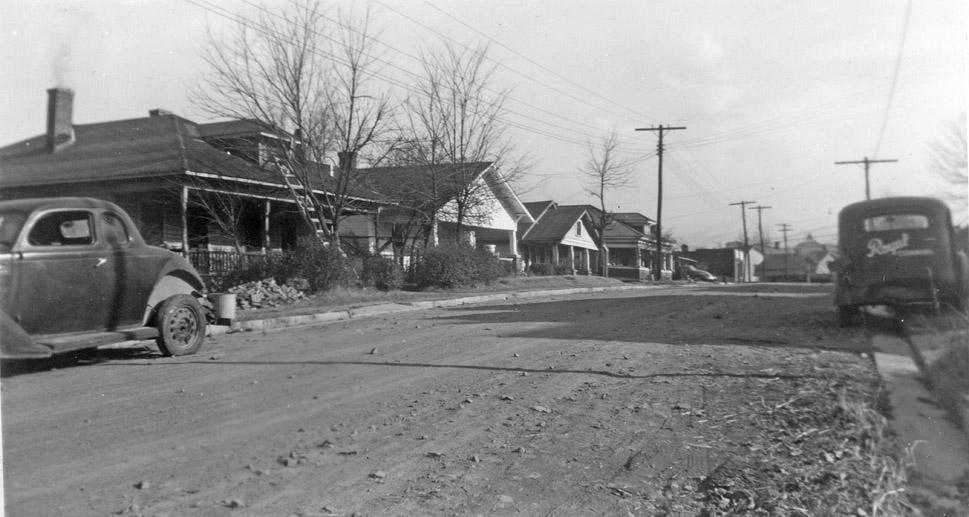
Looks to me like the north side of Wilkerson Ave, taken from approximately the intersection of Wilkerson and Rome. I know that view well, having lived in the second house from the left--now a rental duplex--for several years.
Submitted by elizabeth (not verified) on Thu, 6/10/2010 - 2:49pm
No theories on this image, but just wanted to be sure you & your readers are aware of a new online resource, DigitalNC.org, the website of the new NC Digital Heritage Center.
Of particular interest will be the Durham Urban Renewal Records from the Durham County Library, fully digitized and available online.
Submitted by Gary (not verified) on Thu, 6/10/2010 - 3:11pm
Thanks Elizabeth. Readers can also find a more complete collection of the urban renewal photos online here, as I previously spent a few hundred hours digitizing the urban renewal photos for myself and for the county library before the NC Digital Heritage Center re-digitized them. Currently, DigitalNC.org only has ~1/4 of the records online. I'm sure they will digitize the rest in time. Of particular interest, though, are the actual appraisal records available at the linked site, which I didn't have the time or energy to scan - they provide a wealth of additional information, including ownership, valuation, building footprints, etc.
GK
Submitted by David N. (not verified) on Thu, 6/10/2010 - 4:54pm
I don't think it's Wilkerson. Though there is a house on the north side that looks like the second on the left, those to either side don't match those in the photo. More specifically, I can't find any hipped-roofed houses with central dormers (like the first and last houses in the photo) on Wilkerson.
Submitted by Eli Van Zoeren (not verified) on Thu, 6/10/2010 - 9:17pm
I just checked Google Streetview and David is right. I was mis-remembering the rooflines of those houses. Not sure where it is, then.
Submitted by David N. (not verified) on Fri, 6/11/2010 - 2:37pm
Zooming in, it looks like the last structure on the left may be a commercial building. The road itself appears to T into another road, possibly at an odd angle. In the distance is what appears to be a cupola or possibly a steeple.
Here's an idea: Is it possible to look up the owner of the Royal Cleaners and get a candidate street from their residential address?
Submitted by Michael Bacon (not verified) on Mon, 6/14/2010 - 2:43pm
I've been fighting with this thing for several days now, and I don't have any good candidates. That said, here's the things I noticed in case other folks haven't.
* The angle of the sun and the shadows imply that this is either a shot facing north in the early morning or south in the late evening. Either way, even if it's not directly on a cardinal direction (a crooked street in Durham?!? No, it can't be!), the predominant direction of the street is N-S.
* The cupola in the distance should really narrow this down. It seems to sit on top of either a curved or domed roof. The best match I could find was the mini tower on top of the Reynolds pavilion at NCSSM, but that basically makes this street Iredell, which it doesn't match at all, and there are no commercial buildings to match up with it.
* The "Negro residential street" in 1945, given the sizes and styles of the houses, would seem to imply one of the following areas: Bragtown, Walltown, or the southeastern corner of the city to the north and west of central, including Hayti.
I know that's not much to go on, but I've been spinning on this thing too long to not comment... :)
Submitted by D (not verified) on Tue, 6/15/2010 - 12:47pm
South Street looking toward enterprise
Submitted by Anonymous (not verified) on Wed, 6/16/2010 - 7:51pm
Yep - looking North on South Street. Not too far from the infamous Apex St. bridge.
Submitted by Ricky (not verified) on Wed, 6/16/2010 - 10:27pm
Where at on South St. I can't find anything that looks close to this picture on South looking toward Enterprise St. Where is Apex St. bridge?
Submitted by Ricky (not verified) on Wed, 6/16/2010 - 10:36pm
Looks a little like a house on South St. but the houses are a lot higher than the street. In the picture the houses are about the same elevation as the road. I don't think it would change that much
Add new comment
Log in or register to post comments.