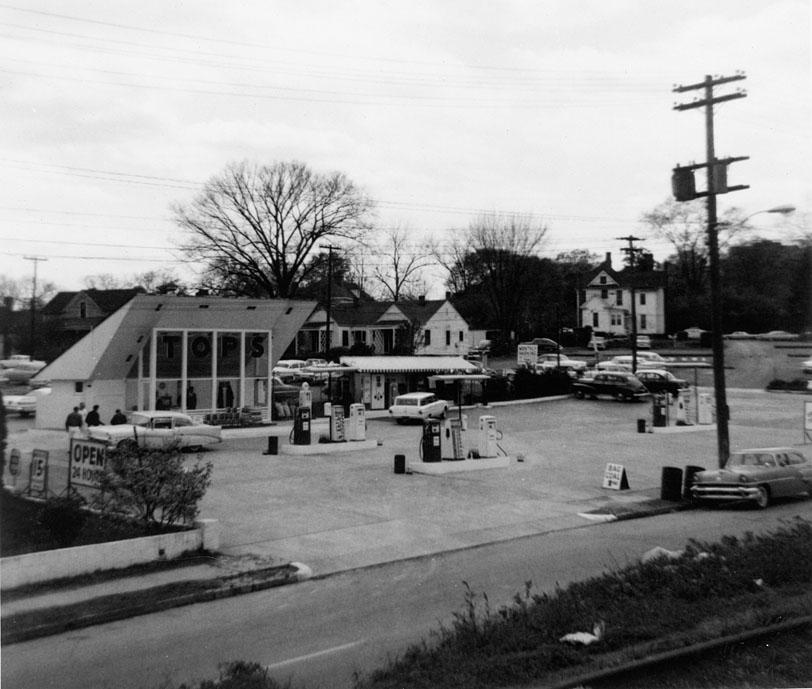
319-321 West Pettigrew, looking southwest, 1965
(Courtesy Durham County Library)
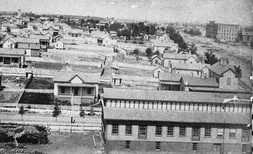
West Pettigrew Street, neé Railroad St., began as a residential street situated between the Blackwell Factory and the Duke Factory
Looking west from the top of the Blackwell Factory, mid-1880s. Carr St. and an early Blackwell's Durham Tobacco building are in the foreground - the houses to the right face Pettigrew and the railroad tracks. The first wing of the Duke Factory is visible in the right background.
(Courtesy Herald-Sun)
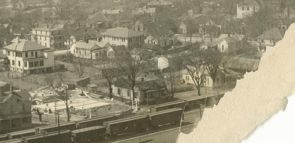
The western portion of the 300 block (which ran between Carr St. and Ashton Place) remained residential through most of the early to mid 20th century
Looking southwest from the First National Bank Building, 1920s - although a tear in the photograph obscures the western portion of the block, several small two story houses are visible.
(Courtesy Duke Rare Book and Manuscript Collection/Digital Durham.)
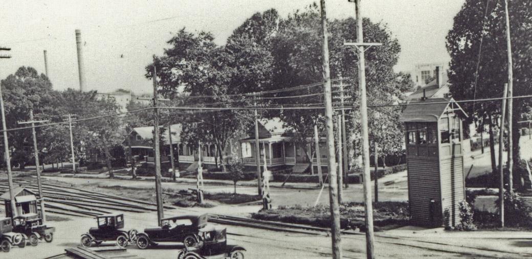
Below, as seen from the West Chapel Hill St. crossing, looking southeast. Ashton Place is the street entering Pettigrew from the south, straight ahead. (Notice that, prior to the overpass construction, Ashton Pl crossed Pettigrew to intersect with West Chapel Hill St.) A bit of the Morehead School is visible in the background as well.
(Courtesy Durham County Library)
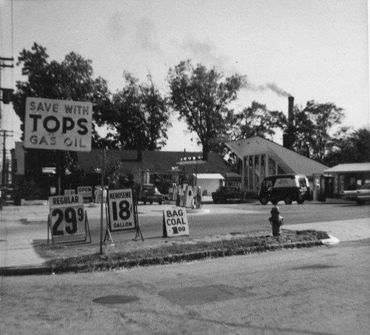
By the mid 1960s, this strip had become entirely commercial - through replacement and conversion of residential structures. Two houses were torn down on the southwest corner of West Pettigrew and Ashton Place to make way for a Tops Service Station.
319-321 West Pettigrew, looking southwest, 1965
(Courtesy Durham County Library)
319-321 West Pettigrew, looking east, 1965
(Courtesy Durham County Library)
(Courtesy Herald-Sun)
These structures were torn down by urban renewal in 1967. The service station persisted a bit longer than the residential structures, but not much.
Looking east, February 1967. The Tops Service Station and 317 W Pettigrew are still standing in this picture, but wouldn't be for long.
(Courtesy Herald-Sun)
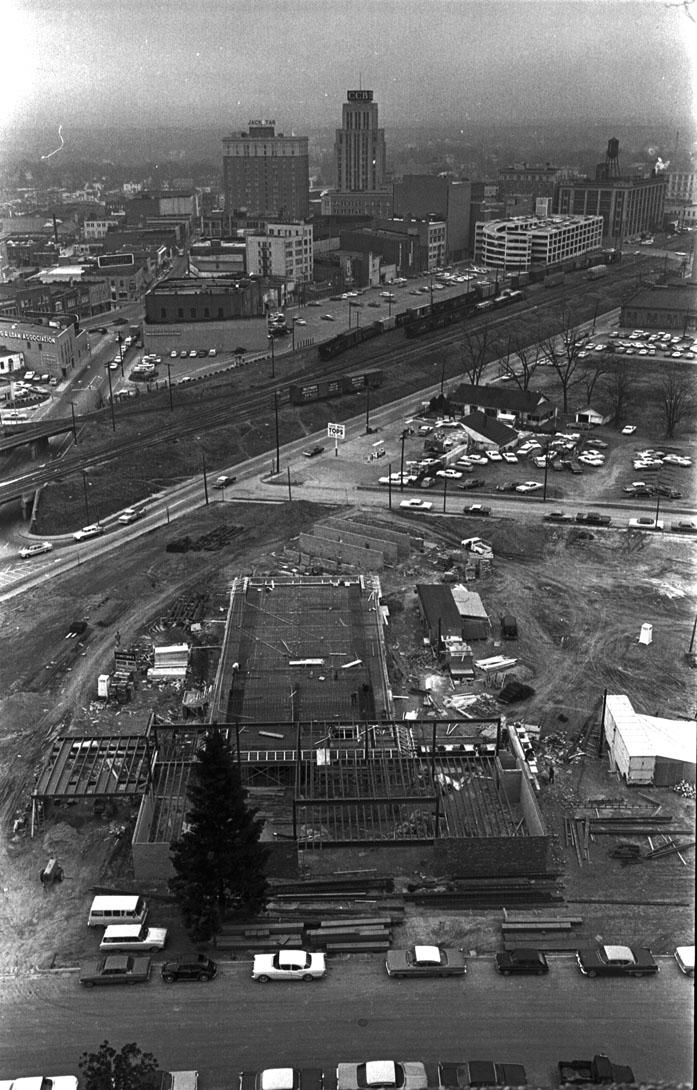
Several other light industrial buildings replaced these structures, most auto and construction.
Looking west from the tracks, 1981.
(Courtesy Robby Delius)
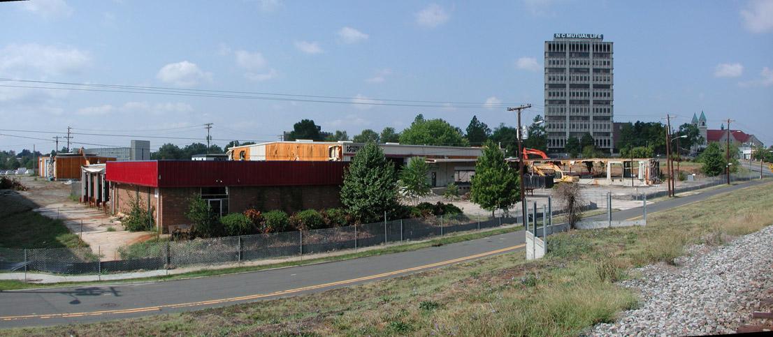
In recent years, these had become Merchants Tire and Ferguson Plumbing Supply. These were purchased by the city several years ago in anticipation of the construction of the new transit station. Demolition of these structures began in September 2007.
Looking southwest, 9.23.07.
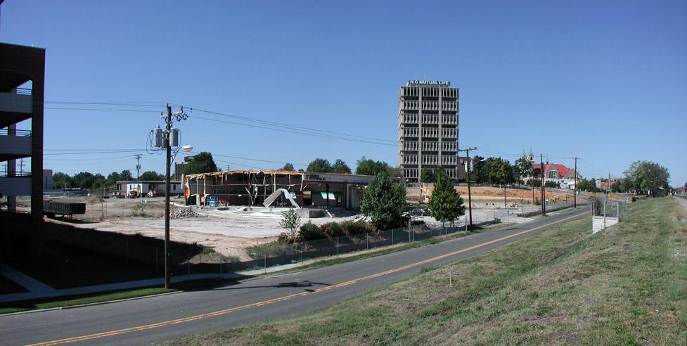
Looking southwest, 11.05.07
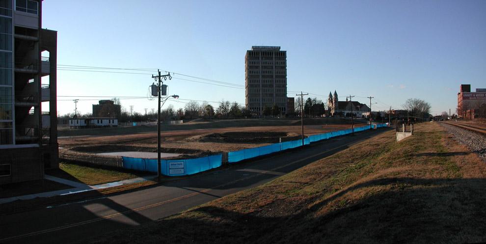
Looking southwest, 12.16.07
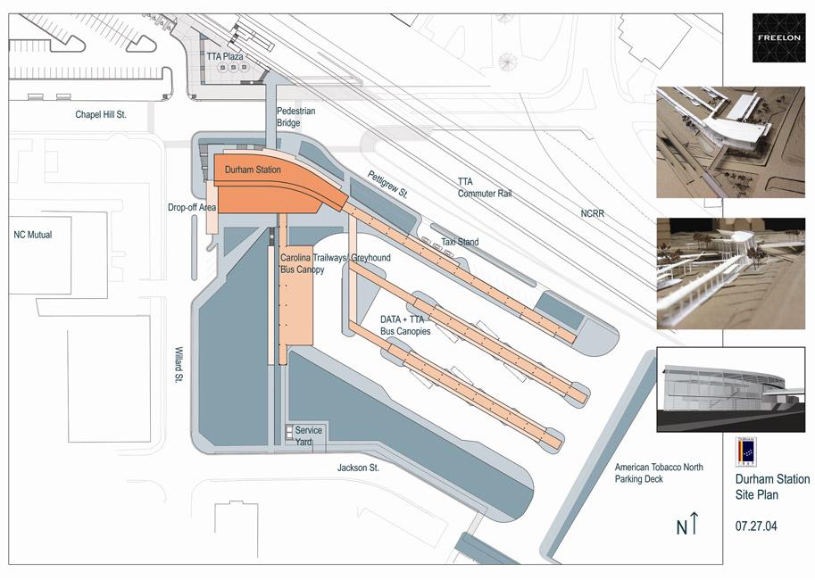
Per a rather old Freelon site plan (2004), this part of the site will be filled with long bus stalls. I don't think this has changed with the RFP, which seems to contemplate private sector development of the Willard/Jackson portion of the site.
(Freelon Group)
All of which means that West Pettigrew is unlikely to be very pleasant walking territory. We can hope this means, however, that Great Jones Street will become more pleasant walking territory, and that future acquisition of the Durham Belt Rail will mean development on the current bus station site adjacent to a walking trail - development that will help link Five Points with the West Village development and Brightleaf.
Comments
Submitted by John Schelp (not verified) on Mon, 2/25/2008 - 1:53pm
15 photographs from then til now. The site plan for Durham Station. Interesting background. Another stunning entry from Endangered Durham.
The walking trail connecting downtown/Five Points with West Village/Brightleaf should be a priority.
A while back, NC State School of Design students recommended a walking trail linking Brightleaf/Smith Warehouse with the Center for Documentary Studies/Ninth Street (also along the RR tracks).
Duke refused to create an opening in the fence around the Smith Warehouse near West Pettigrew/Free Speech bridge. And so it goes.
But, think about it. A walking trail from Ninth Street to downtown. Bridging town and gown; bridging vibrant parts of Durham. What a wonderful and awesome accomplishment that would be.
Submitted by Anonymous (not verified) on Mon, 2/25/2008 - 4:04pm
very interesting as always! Just wondering if you have any idea what the tower structure is at the right of the third photo down? It's so cool looking.
Submitted by John Schelp (not verified) on Mon, 2/25/2008 - 4:30pm
The library's online NC Collection calls it an "elevated tower for crossing guard at railroad."
Here's another photograph... http://dclibrary.net/prod1/ncc/photoarch/oe030.htm
And here's another tower in East Durham (looks like the height is needed to see over the trains)... http://dclibrary.net/prod1/ncc/photoarch/d162.htm
Submitted by Gary (not verified) on Mon, 2/25/2008 - 4:49pm
Thanks all. The tower is, indeed, for a crossing guard who would lower the gates at the crossing.
John, the photo you've linked is mislabeled in the archives; it is actually also of the West Chapel Hill St. crossing.
GK
Submitted by Zack (not verified) on Mon, 2/25/2008 - 5:28pm
This is slightly off subject, but I was wondering if you have or are planning to document the fragmentation of Pettigrew west of Chapel Hill St. It seems like I'm always discovering new 200 yard portions, most recently one at the LaSalle St. intersection the other day. It obviously follows the tracks where possible but I'm curious about its (de)evolution.
Submitted by Gary (not verified) on Mon, 2/25/2008 - 5:47pm
Zack
Eventually I plan to do more of both West Durham and East Durham; Peabody Street has a similar story.
GK
Submitted by John Schelp (not verified) on Mon, 2/25/2008 - 6:12pm
Zack, Here's a little on the gravel section of West Pettigrew, near LaSalle...
Cleanup of Erwin Mills cemetery sheds light on past...
http://www.owdna.org/cemclean.htm
In the past, West Pettigrew did not extend to LaSalle. Folks would bring the coffins out Hillsboro Road -- and then carry them over the RR tracks, west of what is now the Rock Shop. According to Bill Holmes (owner of Ideal Sundry), some people were buried under West Pettigrew, near the tracks.
Here are more photographs on another section of West Pettigrew... http://www.owdna.org/snaps8.htm
Submitted by DC (not verified) on Mon, 2/25/2008 - 11:10pm
I know it was hokey looking, but I kind of like that Tops gas station building.
Submitted by Anonymous (not verified) on Mon, 2/25/2008 - 11:34pm
Reference a connecting trail, what's wrong with the sidewalk along Main street that is already in place? You can walk from the Courthouse to Erwin Square no problem.
Submitted by Zack (not verified) on Tue, 2/26/2008 - 3:09am
Interesting, thanks for the link John.
Submitted by Gary (not verified) on Thu, 2/28/2008 - 1:23am
I have always thought that the area of West Pettigrew near the CDS, to back behind the power plant/Maxwell, across Buchanan to the warehouse were the Duke Surplus used to be, to Duke St. - is really poorly utilized. I'd certainly like to see Duke open it up into something, whether an actual usable street or a trail. To think about a south-of-the-tracks development and a transportation corridor that connected Sam's Quick Shop/Ninth St. with Duke St. is very cool - the kind of thing I wish Duke would embrace.
Submitted by Anonymous (not verified) on Fri, 9/5/2008 - 1:57am
My Mother waited tables in the 4 flames restaurant at the Downtowner in 1968-69, the manager would let this single mother of 4 bring her children to swim in the pool,I was 5 years old at the time. It has been sad to see so much of Durham be Plowed under.
Add new comment
Log in or register to post comments.