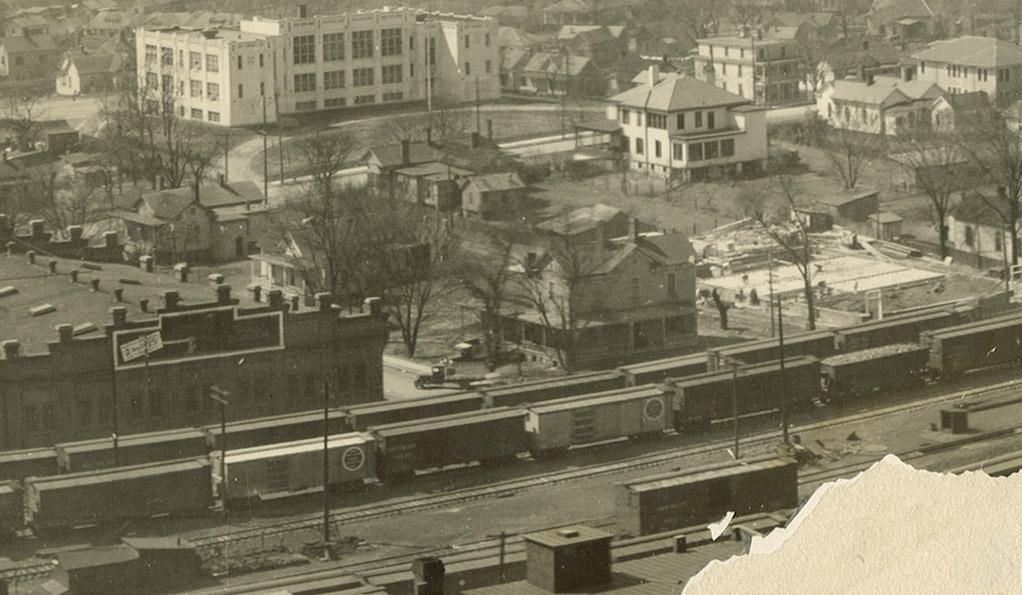
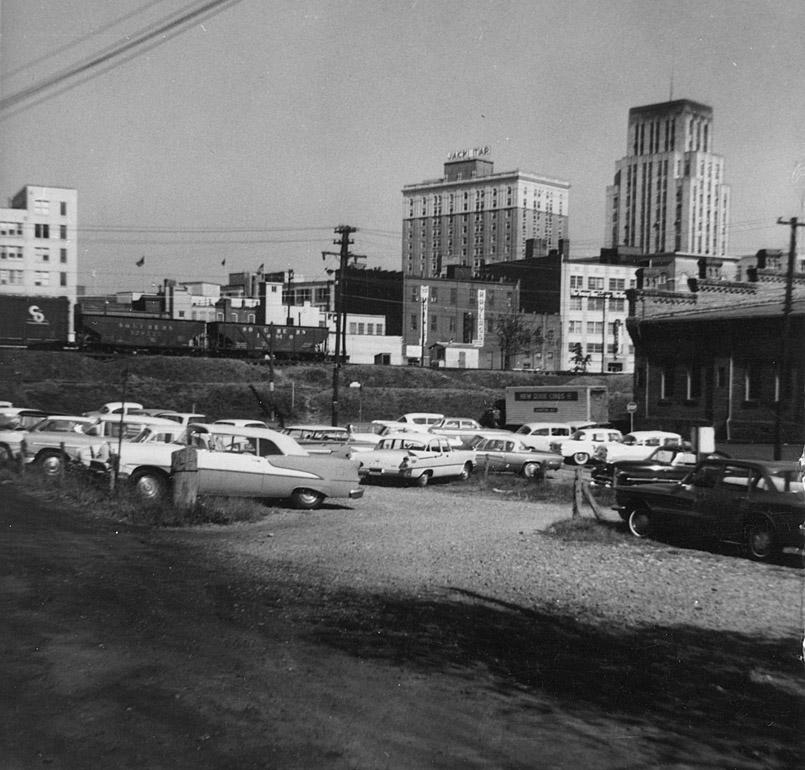
(Fragment of panoramic photo taken for a 1926 Chamber of Commerce booklet, scanned by Digital Durham.)
The house in the center of the top photo and at the right edge of the above picture, two stories and with two chimneys, presents an interesting conundrum - and that is, whether or not it was Julian Carr's first house when he first moved to Durham in 1870. The evidence for this is conflicting and intriguing. An initial observation is that the house, 301 W. Pettigrew St. or 402 Carr St., closely resembled WT Blackwell's house, built on the northwest corner of S. Duke St. and W. Chapel Hill St. around the same time. It is certainly larger than any of the houses around it in the above picture. Hiram Paul, Durham's first historian (who published his history in 1884) notes that Carr gave land for the first graded school (eventually the Morehead School one block south of this house) "near his house on Railroad Street" (which was the first name for Pettigrew Street.) There is, of course, the eponymous street as some small measure of circumstantial evidence.
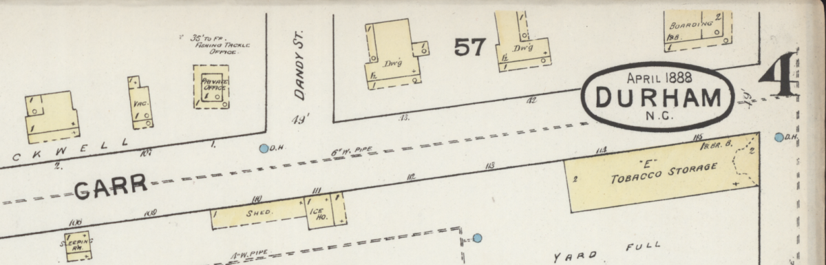
(Sanborn Map Company, April 1888, Fragment of Sheet 4, available online at Library of Congress)
From the top right corner of this 1888 Sanborn Fire Insurance Map sheet, it would seem that - whoever its original resident - the 2-story structure at the Pettigrew corner had been converted to a boarding house by this time and appears to have remained that way through subsequent decades.
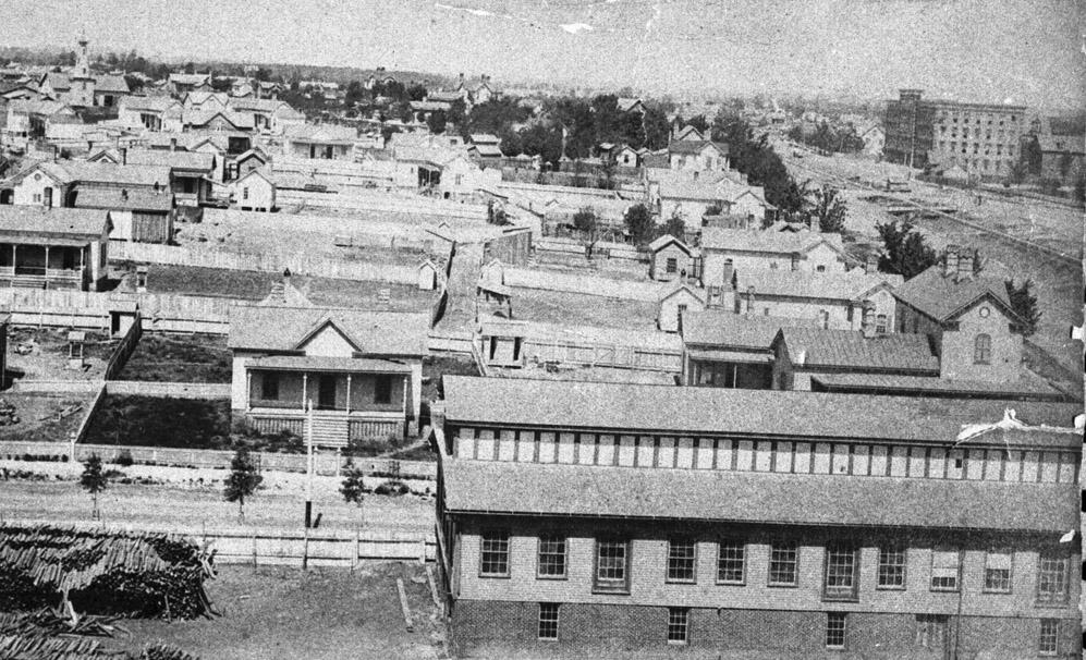
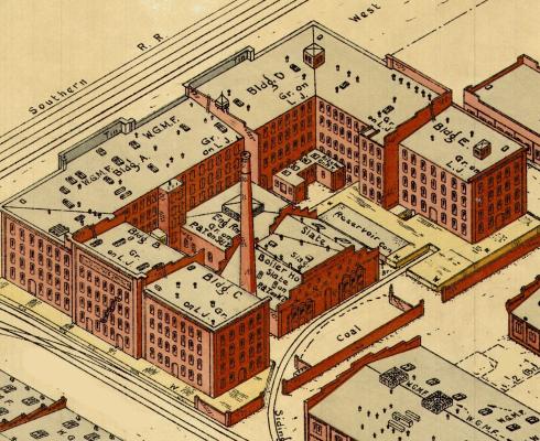
Though of course not accurate in every detail, the oft-reproduced 1891 Bird's Eye map of Durham includes a building on this site that looks a lot like the one in photographs.
(Fragment of 1891 Bird's Eye map, available online at Library of Congress - the house featured here faces the tracks directly below the steaming engine.)
Listed as 301 W. Pettigrew in the 1909-1910 city directory, this boarding house was run by Mrs. Nannie E. Hayes and family. Their tenants that year were said to include tobacco workers John Mooney, Lester Mooney, and J. C. Peace. A carpenter named Norman Proctor and a widow Sallie Rogers are also listed at the address, though their status as boarders is unspecified.
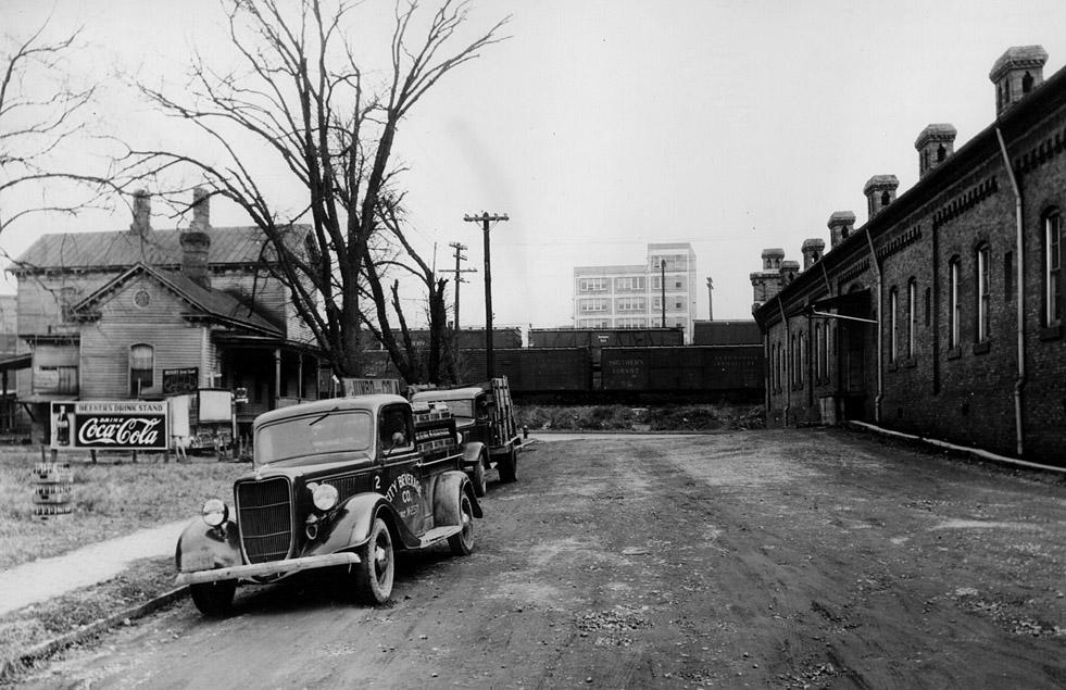
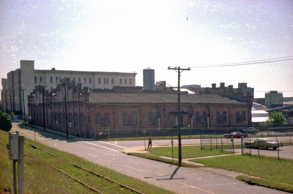
A view of the house from the north side of the tracks, looking southwest, 1920s. The Hill Warehouse at the left of this photo replaced the Reams Warehouse in the earlier shot. (Fragment of panoramic photo taken for a 1926 Chamber of Commerce booklet, scanned by Digital Durham.)
Another view of the back of the house from Carr St., looking north, 1938 (the back of the Snow Building is visible across the tracks.)
(Courtesy Robby Delius)
By the 1930s and 1940s, the building seems to have been subdivided into multiple units and listed as 402 Carr Street rather than W. Pettigrew. Its tenants included both residents and eateries, including the Lucky Clover Inn run by live-in operators Reuben and Helen Kelley in 1940.
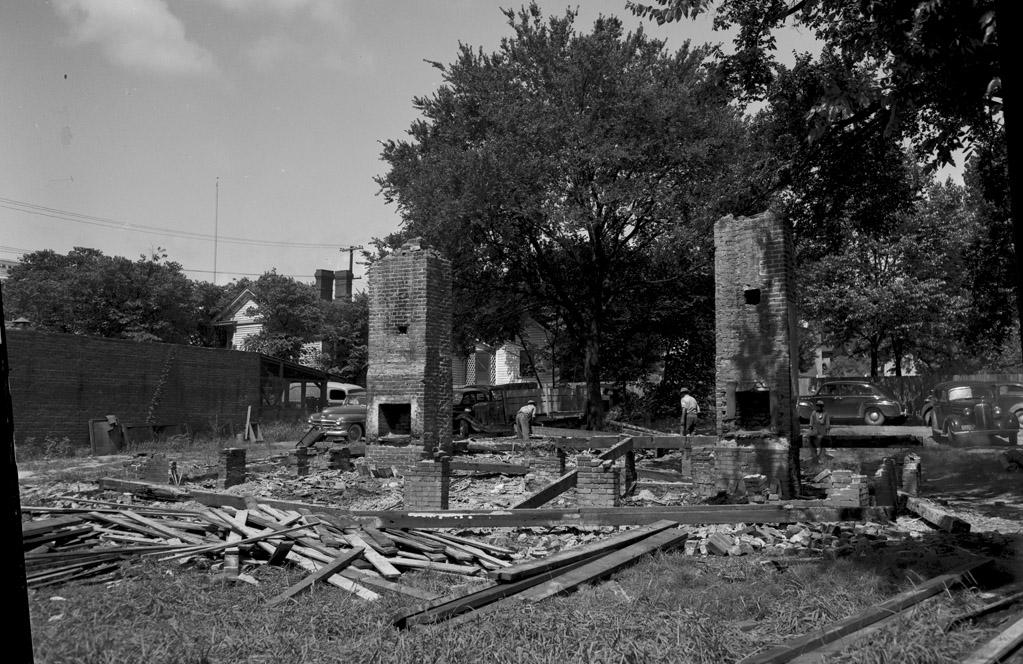
A Durham Sun news article from July 21, 1949, entitled "Carr St. Landmark Torn Down" would seem to provide the most direct evidence that Carr lived on the street - but in the small house immediately behind it, at 408 Carr.
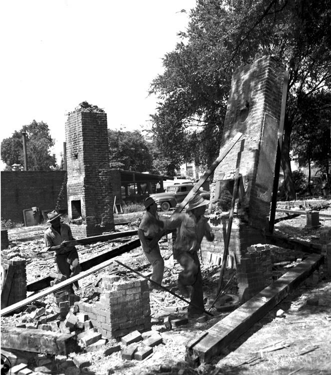
408 Carr being torn down, looking southwest. (Courtesy Herald-Sun)
408 Carr being torn down, looking southwest. (Courtesy Herald-Sun)
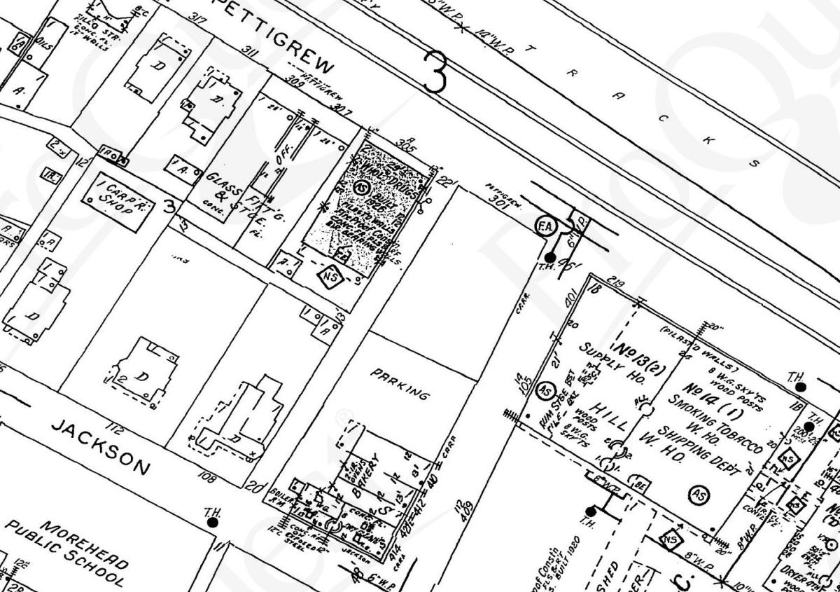
The houses were both razed for a parking lot, as shown in this 1950 Sanborn map excerpt.
(ProQuest Sanborn Maps accessible to Durham County Library patrons via NCLive.org)
Looking northeast, 1965. (Courtesy Durham County Library)
This gravel lot was eventually paved.
Looking southeast, 1981.
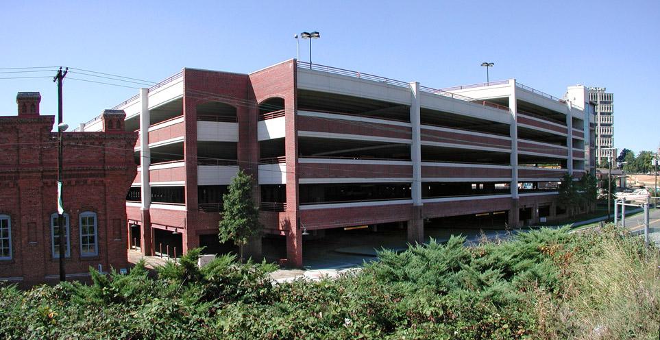
The city took this lot and Carr St. to build a parking deck for American Tobacco, eliminating this corner. I find the closure of Carr St. fairly bizarre and unnecessary, actually. I've heard people claim that it's still sort of a 'street' through the garage - and I drive that route periodically, but c'mon - it's not a street.
Looking southwest, November 2007.
So did Carr live here, where we have a parking deck? (Which provides some continuity with the location of his later mansions, Waverly's Honor and Somerset Villa, now a 400+ space surface parking lot for Durham County.) I don't know - some sources say Waverly's Honor was built in 1870, the same year Carr joined the WT Blackwell firm. But it's a good, as yet unsolved, mystery.
The 1938 photo of this building was the subject of a What's It Wednesday?! post on Open Durham's social media accounts (Facebook and Instagram), the week of May 1, 2019. Follow us and stay tuned for more finds!
Comments
Submitted by Jeremy T (not verified) on Wed, 2/27/2008 - 5:07am
I, too, question the semi-closure of Carr St. here - this "parking deck tunnel" is currently the only way to access the west side of the ATC directly from Pettigrew.
I find the Pettigrew St side of the ATC unwelcoming in general, though I suppose that might improve as some of the construction at the north end of the complex winds down. The renovated Hill warehouse (which I don't believe you've done yet) entirely faces towards the campus center with no North entryway, and there's a pretty wild-looking scrub growth between Pettigrew and the train tracks that partially obstructs the view of downtown. Looking south, the buildings are tall enough (and the sidewalk close enough to them) that they largely obscure the skyline of the ATC. Taken together, this feels almost claustrophobic and generally isolated.
Compare this strip of Pettigrew to the opening at the south of the complex (which allows you a nice view along the entire length), or the somewhat more welcoming streetscape along Blackwell (which at least has some landscaping), or the west side of the Washington building (although there's surface parking here, you do have a nice view of the water tower / smoke stack and the skyline visible above the building).
I do hope the Pettigrew streetscape will improve as the project continues. When they finish that building at the corner of Pettigrew and Blackwell (which they call the "Old Hill Building" - but that's not right, is it?) there should at least be some kind of entry path between it and the Hill Warehouse. The last I looked, this was still fenced off and filled with construction equipment.
Submitted by Gary (not verified) on Wed, 2/27/2008 - 12:43pm
Thanks for the comment, Jeremy; my biggest beef with American Tobacco is that, most pejoratively, it is a suburban program in a historic complex; that is, it is really designed to be accessed by car from the Freeway. It's terrible that this deck 1) has no street-level retail or office and 2) because they closed Carr St., and haven't made any kind of attempt to activate the front of Old Bull (the only "Old" name I know to be accurate), the inactive frontage extends for two contiguous blocks.
I agree with your assessment of Blackwell. And really, although there are two pedestrian entrances on the remaining Carr St., they are strangely disconnected/hard to locate for the uninitiated.
Pedestrians and the southern portion of downtown are caught in a lose-lose situation - developers note that there is no pedestrian traffic, and so they figure they can't lease space to street-level tenants - so they put very little in the way of street level amenity, because it doesn't allow them to charge more rent. So street level activity is minimal, and pedestrians have no more reason to walk from somewhere else. Thus it becomes self-reinforcing that other developers shouldn't build street-level activity.
GK
Submitted by Dave W. (not verified) on Wed, 2/27/2008 - 3:58pm
Got dam but it sure would be nice if the state, city, and historic preservation bodies made specific requirements for stronger street connectivity and pedestrian access, and favoring front doors and welcome mats that face downtown or neighborhoods and not the highway.
Tie these demands into conditions to receive tax breaks and tax dollars. Then the city could begin to have development follow urban planning, not the other way around.
When organizations and developers come asking for dollars make sure they are first considering big picture and diverse audience, not just the out of town visitor/commuter approaching from the freeway and making their life easier to get back on the highway without interacting with a city street.
My wife works at AT and says most of the folks she works with that come from out of town don't interact with downtown. Ever. Disappointing, but this is what the physical design of AT (visually defined as an employment campus) tells them to do, come from the highway, enter your cocoon, park, work, get out and back on the highway.
spoken by someone who appreciates American Tobacco but was hoping for "more better".
I see that now AT is selling itself as an "entertainment center" so maybe they will change their outlook a bit. I always thought it seemed weird that no retail stores, galleries, live music clubs were involved in phase one.
Hopefully their upcoming decisions for phase three will be better and they will put some love into the approaches from different directions.
Submitted by Anonymous (not verified) on Wed, 2/27/2008 - 11:32pm
Perhaps since you have so much time on your hands, you could spend a few days perusing land deeds for the property?
[Ok, I am being very sarcastic]
But if some research-minded ED reader did have some "extra" time, he/she could look at deed book 4078, page 108 (plat book 159, page 235) and go back from there to see who owned the lot way back when. The city owns it now, by the way (its PIN is 0821-12-87-0291, again btw).
Submitted by Gary (not verified) on Thu, 2/28/2008 - 1:16am
DW
It would be great, but I'm not sure the city - given that they built this parking deck - really gets it. I did notice that AT has actually put some signage out on Blackwell Street now. They could have enlivened that street so much.
Anon
I nominate - you! :)
GK
Submitted by Dave W. (not verified) on Thu, 2/28/2008 - 3:22pm
re: signage.
was very delighted to see the YMCA sign on Blackwell street.
Not only is there a sign now on Blackwell, but it is actually pretty darn cool.
kudos to the Y.
Add new comment
Log in or register to post comments.