Support OpenDurham.org
Preserve Durham's History with a Donation to Open Durham Today!
OpenDurham.org is dedicated to preserving and sharing the rich history of our community. Run by our parent nonprofit, Preservation Durham, the site requires routine maintenance and upgrades. We do not ask for support often (and you can check the box to "hide this message" in the future), but today, we're asking you to chip in with a donation toward annual maintenance of the site. Your support allows us to maintain this valuable resource, expand our archives, and keep the history of Durham accessible to everyone.
Every contribution, big or small, makes a difference and makes you a member of Preservation Durham. Help us keep Durham's history alive for future generations.
Comments
Submitted by Anonymous (not verified) on Thu, 9/24/2009 - 9:37am
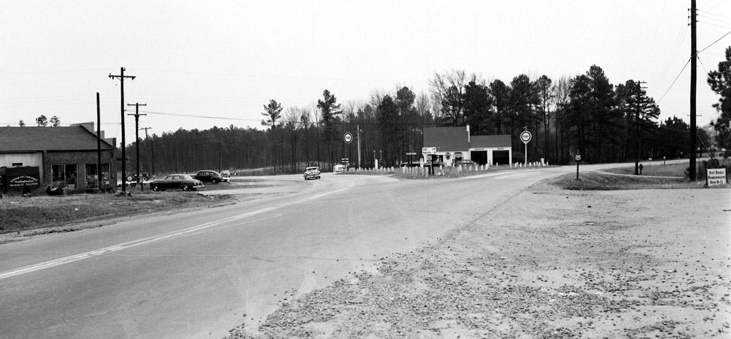
Is this the Highway 70 / Miami Blvd split? If so, S. Miami is on the right, looking toward Bethesda; US 70 is on the left, looking toward Raleigh. Google Maps calls this stretch of 70 the "new Raleigh highway". The old Raleigh highway might have been Angier to S. Miami. Another route to Raleigh was Angier to Leesville Road.
Submitted by Batman (not verified) on Thu, 9/24/2009 - 10:24am
I agree with Anonymous. That stepped-front building on the left is still there isn't it? If this is correct, the 70/left fork is pretty curved.
Submitted by Michael Bacon (not verified) on Thu, 9/24/2009 - 12:56pm
I have no idea if 70 actually ever came down Avondale, but to my eye, this shot is what the terrain and curvature of the road reminds me of.
The other place it could be is at the 70/Old NC 10 split just past the 751 intersection west of town, but I wouldn't think it would be called the "Raleigh-Durham highway," and Old NC 10 is incredibly straight there.
Submitted by Anonymous (not verified) on Thu, 9/24/2009 - 2:30pm
Bethesda it is! The site of the Service later became Strayhorn's Service Station that also operated a towing company as well.
Submitted by Amy G. (not verified) on Thu, 9/24/2009 - 6:09pm
So, that means the Pure station is where the Exxon/McDonald's is now? The topography beyond that in the picture definitely looks like that now. I pass by that intersection every day and it looks very familiar.
Submitted by Jeremy (not verified) on Thu, 9/24/2009 - 6:57pm
For this to be Bethesda at Hwy 70 and Miami, the foreground would have to be Sherron. But it would have to be a Sherron that ran thru what is now the Burger King. Otherwise, the orientation of that "stepped bldg" (which is now a much larger warehouse) is wrong. And Miami/70 would be to the lower right and have been gravel? Not making sense to me.
I don't have another suggestion though...
Submitted by Paul (not verified) on Thu, 9/24/2009 - 7:51pm
Jeremy, the road you think is missing may be next to the building with the stepped facade. It looks like a driveway, but it could be a really small road. While it's Sherron now, it was Mineral Springs before a rerouting circa 2002.
Submitted by Jeremy (not verified) on Thu, 9/24/2009 - 8:41pm
@Paul, what I'm saying is that present Day Sherron is too far away from the warehouse to be the road in the picture. That road in the foreground of the photo is almost right next to the bldg. Seems odd that a driveway would have the double yellow line, but it's possible. That "stepped bldg" does look a lot like the bldg at the 70/Miami/Sherron intersection...
Submitted by Gary (not verified) on Fri, 9/25/2009 - 12:28am
I looked back at the original photo. The directional sign at the crossroads says Raleigh is 18 miles to the left, Cary 13 miles to the right. There is also an Oak Grove sign to the left.
GK
Submitted by Anonymous (not verified) on Fri, 9/25/2009 - 2:46am
Indeed, that is the Miami/70 intersection.
Paul is correct, Sherron Road used to dead end at the intersection of Mineral Springs about 1/4 mile or more from 70. If you drive around, it's not hard to see where it was.
I grew up on Mineral Springs-born in '68 and my parents still live there. The building that Batman sees to the left is what became/was Town & Country Furniture. It was torn down in the mid or early 80's from what I remember. It seems like they had a fire or something that damaged the building. There appears to be farm equipment in front of what is now Phillips Electric/Product Recovery/Triangle Stainless. I'll ask Mom if she knows what was there. That used to be some sort of metal shop in the 70's and 80's when I lived in the area.
The late J.O. Strayhorn did indeed run that gas/garage in the center. It was a 76 station for as long as I can remember. Interestingly, there was a Sinclair(I think) station to the left in this pic operated by a Mr. Adams. I would have thought that it was there by the time this pic was taken. I know the son of the former owner. It would have been on the site where Suntrust now resides. That station was still in operation as a tune-up garage 10-12 yrs ago. CCB/Suntrust rebuilding the bank and DOT expanding the intersection eliminated that old station/garage.
There is a 'hot dog' stand to the right. In the early 70's that was also likely the place that I used to get ice cream-can't remember the name-I'll ask Mom. Where the pawn shop to the right now sits used to be a convenience store-the 'Lil' Rebel'. There was also an ABC store to the right of that connected to the store.
Great pic, Gary! Thanks for getting something from out in the county!
Seth Roberts
seth@realtor.com
Submitted by Wayne Henderson (not verified) on Fri, 9/25/2009 - 3:12am
Gary:
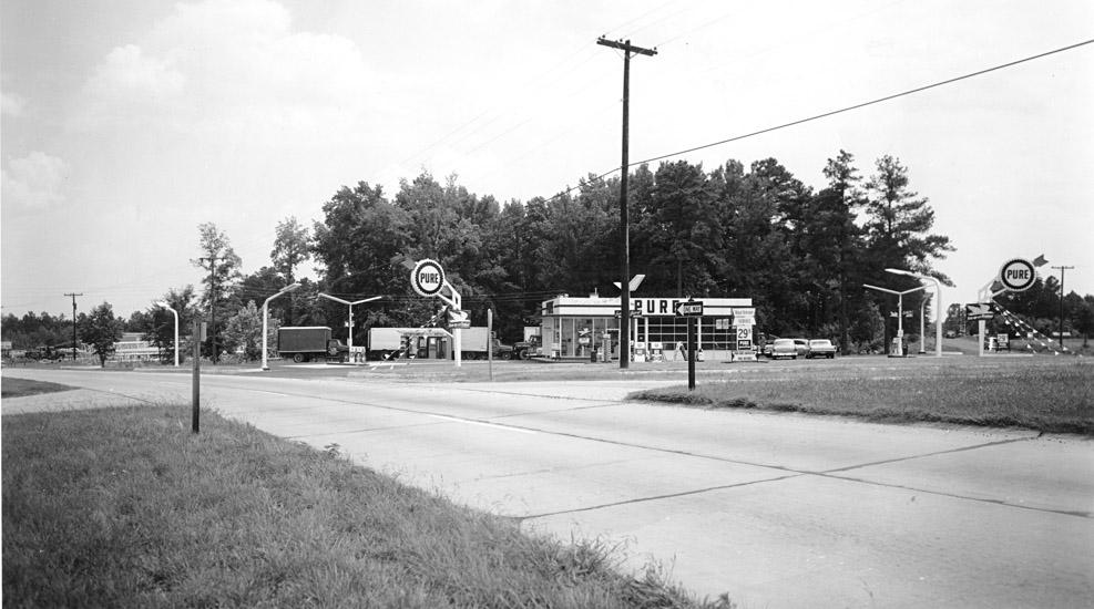
In those Durham service station photos I sent you about a year ago there is a 1962 photo of a later generation Pure Oil station that replaced the Pure cottage seen here. I displayed both to compare and the scene matches. It might be good to run them together on the site.
Wayne Henderson
Submitted by Anonymous (not verified) on Fri, 9/25/2009 - 2:43pm
Mom corrected my memory and added some info:
The store that would have been to the right was not the Lil' Rebel-The Lil' Rebel was at 98 and Mineral Springs. It was the Lil' General at Mineral Springs/70/Miami.
Also, she said that the station that would have been on the left was Adams Texaco, not a Sinclair from her memory. Perhaps it was Sinclair earlier???
The ice cream shop to the right was owned by the Dean's. She can't remember if that was the name of the business. She remembers there being a furniture store to the right prior to the Lil' General being built.
The Town n' Country Furniture store was replaced by the now present Burger King and Pizza Hut behind it.
Going past the Pure station towards Raleigh there is now a junky trailer park-what's left of it-that used to be some sort of an amusement park with hobby horses, snacks etc. Perhaps an early version of a rest stop between Raleigh and Durham.
To the right down Miami, the Bethesda Volunteer Fire Co./Dept. and the Ruritan Building.
Seth Roberts
seth@realtor.com
Submitted by Toby (not verified) on Fri, 9/25/2009 - 8:18pm
Per Seth's description, you can clearly see the old alignment of Sherron and Mineral Springs on Google maps:
http://tinyurl.com/yc768zc
The old Sherron is stub is still labelled "Sherron Rd", and you can see where Mineral Springs formerly continued straight down to 70 after Sherron's T intersection with it.
Submitted by Anonymous (not verified) on Sat, 9/26/2009 - 2:28am
I also remember that amusement park, it had a very large sign out front that said "White Only". When I was 8 years old I could not understand the reasoning for it. Now that I'm in my late 50's I know why the sign was there. I am glad times have changed.
Submitted by X Durh Chik (not verified) on Wed, 9/30/2009 - 5:11pm
Dear Anon,Could the metal shop you are talking about have been East Coast Distributors?
Submitted by Carol (not verified) on Sat, 10/29/2011 - 2:58pm
The amusement park that is referred to was further down on 70 toward Raleigh, it was owned by the Veasey family. It was my first and last time riding a roller coster. I went to school with their son. It is now used by a mobil home company.
Submitted by Anonymous (not verified) on Wed, 12/21/2011 - 9:51pm
The latter picture is definitely Strayhorns, where the Exxon/Mcdonalds is now. Adams Texaco was diagonal, and Town and Country Furniture is where Burger King is now. I grew up in that neighborhood, hung out at Strayhorns. I also remember the amusement park further down 70 that the Veasey family ran. I LOVE these old pics!! Anyone got any of the flintrock store down Miami where Tommys Mini Mart is now? Jeffs Auto Service and Grill was across Angier Ave, Andrews Produce, a barber shop and Clements (I think) ice house was on Angier across from the flintrock store (Ferrells), and Chandlers was diagonal from Ferrells.
Submitted by Mel Phillips (not verified) on Fri, 1/16/2015 - 9:51pm
My brother and I own Product Recovery Management/Triangle Stainless and the former Phillips Electric Co. of Durham, Inc. which was our parents. We have moved the company to Butner this year as we needed to expand and we now have the former Athol Facility which has about 250,000 sqft and 15acres....(plus 1000 new solar panels). Anyways, if anyone has other older images, it would be great to add. I had heard that where the Burger King is was a gas station at one point also, but that was just hearsay. Any information would be great to see.
Add new comment
Log in or register to post comments.