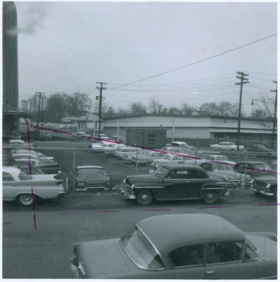
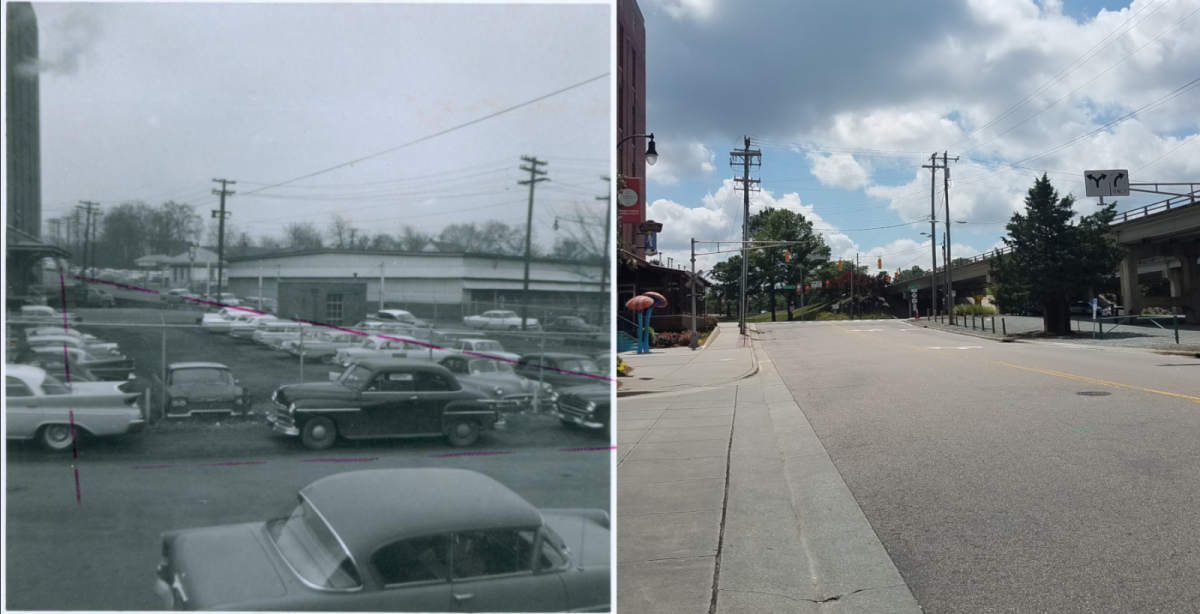
Photo likely taken early in 1963 shows 207 Morehead Avenue in the right background, with the Lucky Strike Service Station in the distance and American Tobacco's Fowler Building at the left edge (From Durham Urban Renewal Records, Box 1. Courtesy of Durham County Library - North Carolina Collection, available online at DigitalNC.org)
From the late 1930s until their demolition to begin construction of the Durham Freeway in 1967, a pair of warehouse buildings used by the American Tobacco Company were listed right where Carrington Street and the factory's southbound supply railroad intersected Morehead Avenue.
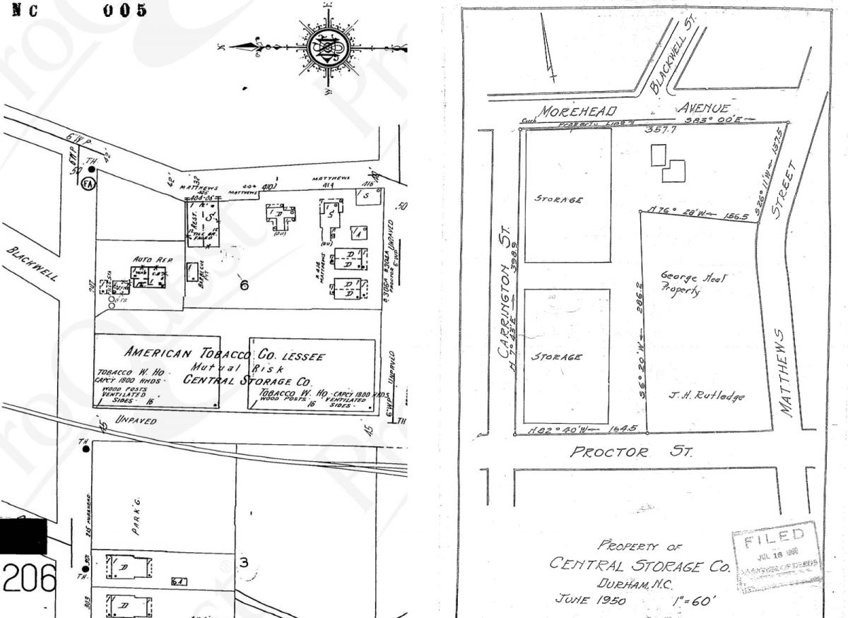
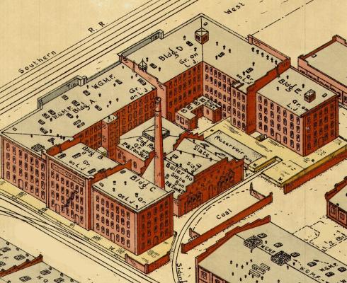
Fragments of 1950 Sanborn Fire Insurance Map (ProQuest Sanborn Maps available online via NCLive.org) and a plat map showing the property from the same year (Durham County Register of Deeds)
It appears the buildings were actually leased from Central Storage Company before American Tobacco purchased them outright in 1950.
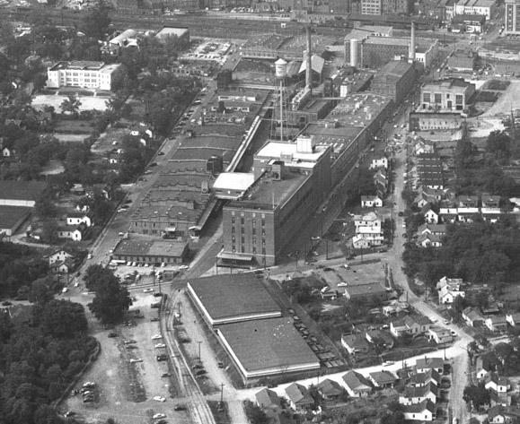
Aerial view of the American Tobacco factory complex looking north with the warehouses at 207 Morehead Avenue in the foreground, 1950s (Courtesy of the Herald-Sun). Note also the rows of mill houses still standing along Matthews (right), Proctor (bottom), and Carr (left of the factory) Streets - all demolished in years to follow.
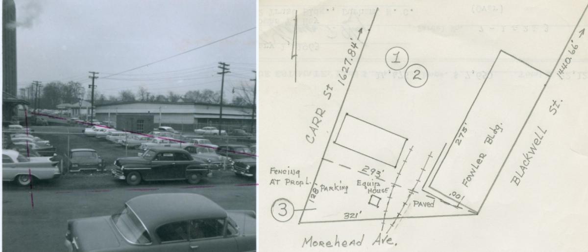
The top image from the early 1960s - reproduced at left below - holds clues as to the fate of these unassuming structures and the surrounding area. The triangle drawn in dotted purple lines marks the then-existing right-of-way for Morehead Avenue (the diagonal) and Carr Street (in the foreground). The third line demarcates a wedge of American Tobacco property being assessed for purchase by the Durham Redevelopment Commission.
The triangular parcel labeled #3 in the sketch at right matches the one outlined on the image at left (Both from Durham Urban Renewal Records, Box 1. Courtesy of Durham County Library - North Carolina Collection, available online at DigitalNC.org)
Valuing the land at 75 cents a square foot and tallying the 'improvements' - the small brick equipment house at center, fencing, and paving - the Commission figured it could slice this corner off the factory complex for just over $22,000 (which would be more like $185,000 in 2019 accounting for inflation). While that represents just a drop in the enormous bucket of appraisals and acquisitions the Redevelopment Commission carried out over the next decade, this little sliver between the factory and its warehouses on Morehead Avenue proved crucial for one of urban renewals flagship projects in Durham.
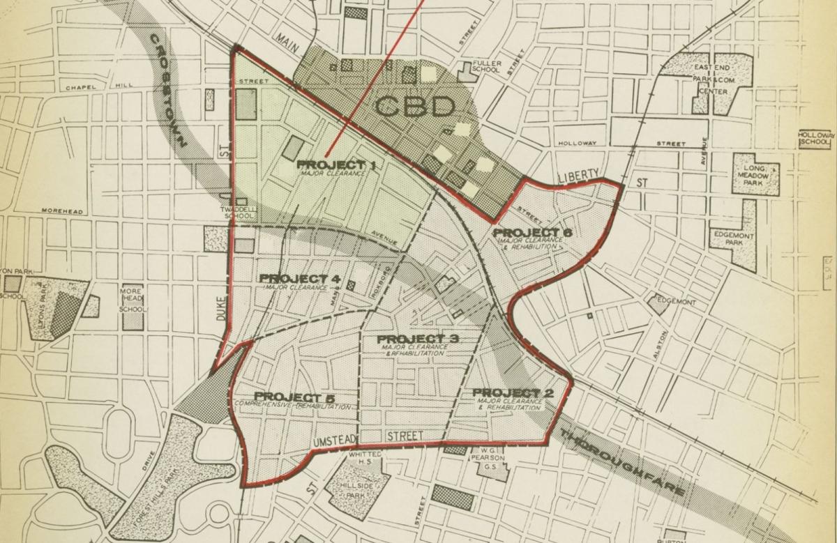
1961 plan for projected zones and phases of urban renewal showing intended path of 'Crosstown Thoroughfare' that would become the Durham Freeway (from page 15 of "Project 1 Land Use Survey" in Durham Urban Renewal Records, Box 2. Courtesy of Durham County Library - North Carolina Collection, available online at DigitalNC.org)
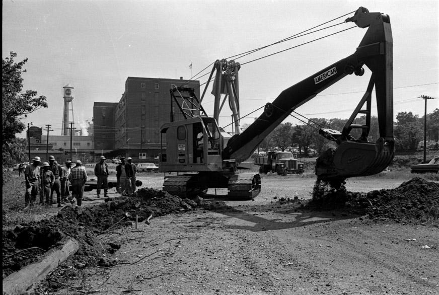
The location of the above-mentioned parcel and the warehouses to its south was at the geographical center of these plans - see where Morehead Avenue intersects the rail line and the grey path of the future highway, right at the border between Project 1 and 4 (both slated for "Major Clearance"). Vital to the planned course of the freeway, this site would also win the dubious honor of hosting its groundbreaking, with work on the new road kicking off right here in the spring of 1967.
"Expressway Started, Morehead Avenue - 05.08.1967" (Courtesy of the
Herald-Sun)
In a city then still full of older structures and non-descript warehouses, perhaps nobody mourned the loss of these thirty year-old buildings - which would have been on the right side of the above image - but there were also residences and business along this strip of Morehead Avenue. And these were just the first scoops of earth in a project that would tear Durham in two at its center, a divide that in many ways lives on more than a half century later.
Then and now...(at right, 07.11.2019 by N. Levy)
This building was the subject of a What's It Wednesday?! post on Open Durham's social media accounts (Facebook and Instagram), the week of July 10, 2019. Follow us and stay tuned for more finds!
Comments
Submitted by Keith Bowden on Fri, 7/12/2019 - 3:09pm
Great post, Nick, and good detective work. I've seen pictures of those two warehouses on this site and I've oftened wondered about them since I use the American Tobacco Trail pretty frequently. Seeing the houses peeking over the tops of them from over on Matthews Street helps put the changes to the area in perspective.
Add new comment
Log in or register to post comments.