Support OpenDurham.org
Preserve Durham's History with a Donation to Open Durham Today!
OpenDurham.org is dedicated to preserving and sharing the rich history of our community. Run by our parent nonprofit, Preservation Durham, the site requires routine maintenance and upgrades. We do not ask for support often (and you can check the box to "hide this message" in the future), but today, we're asking you to chip in with a donation toward annual maintenance of the site. Your support allows us to maintain this valuable resource, expand our archives, and keep the history of Durham accessible to everyone.
Every contribution, big or small, makes a difference and makes you a member of Preservation Durham. Help us keep Durham's history alive for future generations.
Comments
Submitted by wren (not verified) on Mon, 3/30/2009 - 9:35am
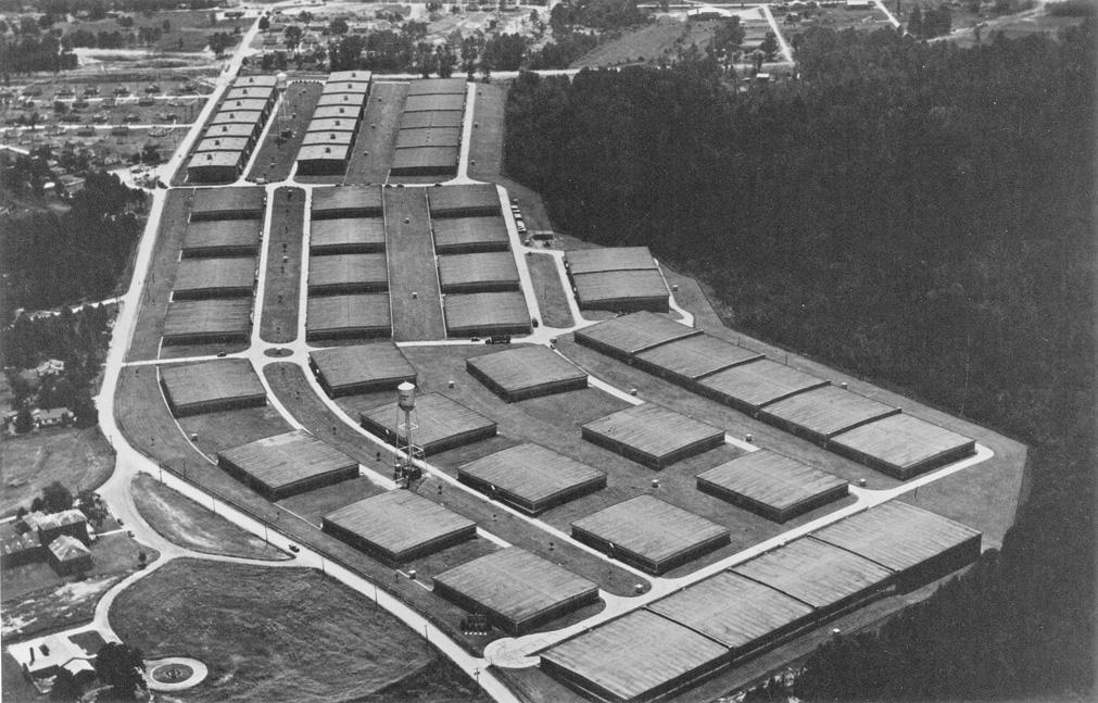
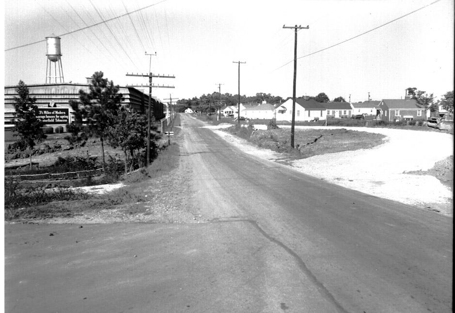
Well, that certianly looks differnet. Not really any better, but different. Great photographs, though. The aerial shots are really intersting to me.
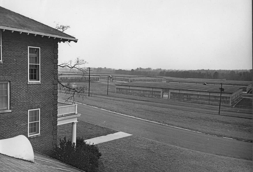
Seems like I remember those being empty as early at 1979-1980 and discussion about what to do with them was going on even then.
Looking forward to seeing what you have on the old TB center/WTVD building!
Submitted by Michael (not verified) on Mon, 3/30/2009 - 1:51pm
Wow thank you so much for this review! My grandparents house used to be right across the street from the warehouses off Broad St so they and/or the water tower usually ended up being in pretty much at least 1 pic at any family gathering. I used to hear stories from my grandparents, who bought their house brand new in 1948 (for like $5k or so) about swarms of tobacco bugs in the summer. The warehouses seemed to be kept neat and tidy into the '80's but by the '90's the fence at the property line had started looking quite overgrown. Thankfully my grandparents had both passed away before they completed the re-development of the site around 2000/2001 as traffic in that area has increased substantially, not to mention the city took some land from the existing residential area instead of the redevelopment area to widen Broad St. I can even see my grandparents house in that pic looking up Broad St! Thanks again, very cool review!
Submitted by Marsosudiro (not verified) on Mon, 3/30/2009 - 3:16pm
Just curious -- do you consider this big teardown a bad "loss" for Durham heritage and/or architecture?
Personally, I would have liked to have seen one or two stay up. But they didn't seem like they were built for the longterm, and thus not for adaptive reuse.
They were pretty darned dramatic, though. And a distinctively ugly (to my eyes) green.
Submitted by next time (not verified) on Mon, 3/30/2009 - 3:58pm
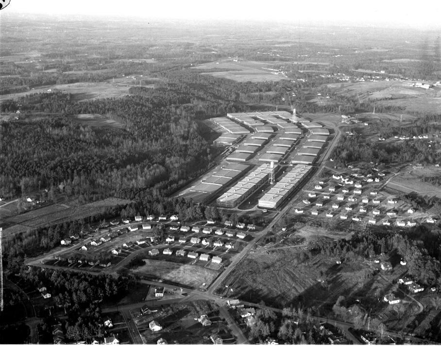
do you happen to know the exact dates of the first two pictures? or know exactly when 70 was cut? the 1st seems to clearly show 70 while the 2nd does not. just curious.
thanks for another fantastic post!
Submitted by carl (not verified) on Mon, 3/30/2009 - 7:09pm
When I was growing up in Durham during the '50s and '60s, I seem to remember that the grounds around these warehouses were maintained by a small herd of sheep. These animals kept the grass neatly trimmed.
Submitted by Anonymous (not verified) on Mon, 3/30/2009 - 9:41pm
Really enjoyed todays post. I though you and others would enjoy more of the story. My parents moved to Broad Street, north of the tobacco warehouses, in 1956. I am now living in the house I grew up in on Broad St. The pictures certianly brought back so many memories. Back in 1956, Broad Street was know as Newton Rd. Several years later, the name was changed to Broad Street Extension. Finally at some point, the "Extension" was dropped. I remember the house numbers changed when the street name was changed from Newton Rd. to Broad St. I also remember the "tobacco bugs" very well. In the summer, with windows open before air-conditioning, the tiny bugs would get into the house occassionally. Thanks again for all your work! Your post often becomes one of the highlights of my day.
Submitted by Elizabeth M. Johnson (not verified) on Tue, 3/31/2009 - 9:44pm
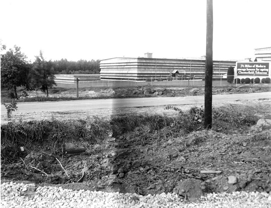
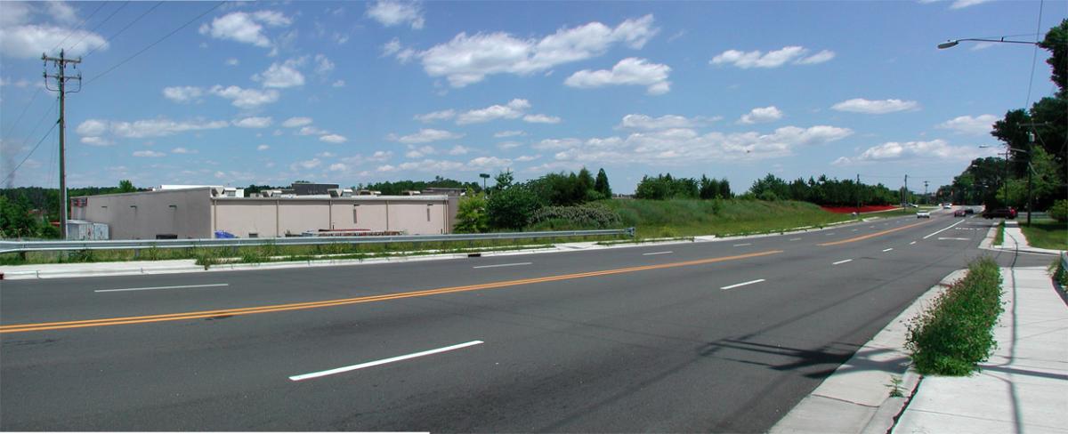
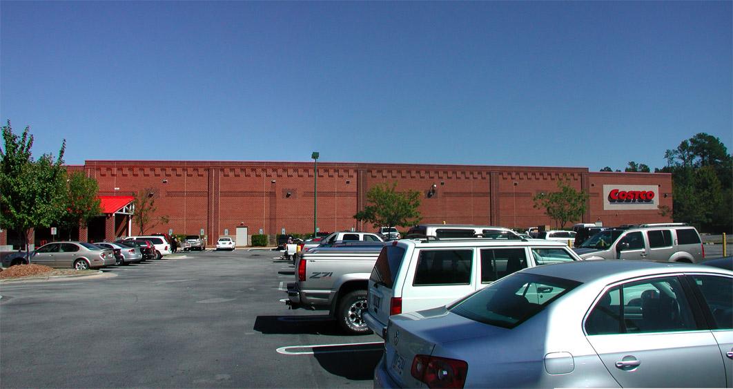
Thanks for another fascinating post! I agree with Marsosudiro that I would like a few of the warehouses to have remained standing. They are/were local history that, I think, should have been preserved. I think that it's incredibly ironic that there is now a Costco (as you state, another warehouse) where the old warehouse(s) used to be. What goes around. . .
Submitted by Anonymous (not verified) on Mon, 4/6/2009 - 3:15am
I believe that at one time the city annexed the Broad street area where the warehouse were located and L & M protested this. They threaten to move the warehouses if they were annexed. The city annexed around the warehouses. The warehouse area was an county island within the city limits. I have no proof on this but that was the tale when that area was annexed.
Submitted by Anonymous (not verified) on Fri, 7/3/2009 - 9:44am
Growing up in the early 90s, I remember when I left the pediatrician's at Central Medical Park that there would be this fantastic expanse of ruined... something out on Broad Street. From a child's perspective, it was like there was this entire disintegrating kingdom that just stretched off to the horizon. And then one visit, it was gone.
Submitted by Ryan (not verified) on Tue, 7/27/2010 - 6:37am
These are some great pictures. I can see my house I've been living in for the past 4 years in the first picture.
Submitted by kinrobby on Sat, 11/12/2011 - 10:53pm
can someone till me what the bulding was between guess rd and broad st it was a round building and u could see if off interstate 85 between guess road and broad it was taken down in the early 90s i remember as a kid my mom saying if she ever caught me in there she would kill me now im wondering was it a strip club. i think the texas steakhouse it in the location now.
Submitted by A Local (not verified) on Sat, 12/7/2013 - 8:19pm
I remember growing up in this neighborhood - in the '90s it was just this row of abandoned buildings we would pass frequently on Broad St. The overgrowth was so thick you could barely see the first row - I had no idea how deep it went and how big a complex it was. After they tore them down, they also took down most of the fencing and as a teenager I walked through those lots and was amazed at how huge an area it was. And now... Well, it is what it is.
Submitted by PiscesMike (not verified) on Sun, 6/8/2014 - 10:04pm
Woooo boy, let me tell you. I lived in this area too.. (well a little bit away), but as a rowdy rebellious teen, we used to go exploring in there all the time. It certainly was a "disintegrating kingdom" as some one mentioned above. If you were brave enough to forge your way in, that place provided hours of fun. We used to go hang out there at night, and climb the water tower. There was something about the solitude and sheer decrepit state that felt like something out of a 'Mad Max' movie. I can't tell you how many times I sat atop that tower with a 12 pack watching the sun come up and the sporadic traffic passing by on broad street.
Submitted by rdelius (not verified) on Tue, 6/10/2014 - 8:55pm
The round building on the old posting was part of the Voyager Inn/ Ramada Inn complex. In later years a flea market
Add new comment
Log in or register to post comments.