Support OpenDurham.org
Preserve Durham's History with a Donation to Open Durham Today!
OpenDurham.org is dedicated to preserving and sharing the rich history of our community. Run by our parent nonprofit, Preservation Durham, the site requires routine maintenance and upgrades. We do not ask for support often (and you can check the box to "hide this message" in the future), but today, we're asking you to chip in with a donation toward annual maintenance of the site. Your support allows us to maintain this valuable resource, expand our archives, and keep the history of Durham accessible to everyone.
Every contribution, big or small, makes a difference and makes you a member of Preservation Durham. Help us keep Durham's history alive for future generations.
Comments
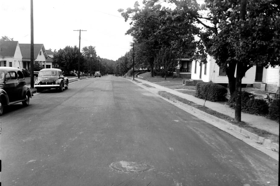
Submitted by Andrew Edmonds (not verified) on Thu, 5/27/2010 - 12:54pm
Is that a church on the right?
Submitted by Anonymous (not verified) on Thu, 5/27/2010 - 1:03pm
I know there are a million hills like this but somehow my first instinct was that this in the Lakewood neighborhood - I don't live anywhere near Durham anymore, so can't think of the name, but it feels like one of the roads on that hill from Lakewood to downtown...
Submitted by Michael Bacon (not verified) on Thu, 5/27/2010 - 1:39pm
The style of houses, direction of the light, and topology of the road is a dead ringer for Englewood through Old West Durham. If it were looking west from the intersection with Carolina, there's a house that matches the one with the five exposed roof joists (is that the word?) on the left at the intersection with Hale, but I don't see a good match for the nearer house on the left.
The banking of the sides of the roadways is also off, but as I discovered when I dug down next to the street in front of my house and found brick pavers 7 inches deep, that topology shifts more than we usually think it does.
Submitted by Paul (not verified) on Thu, 5/27/2010 - 2:02pm
It appears to be a middle-class neighborhood in the 1940s. (It's hard to date this era from cars alone, because WWII stopped car production.) The pavement seems to be the focus of the picture, and there's a high contrast between the dark roadway and light curbs. Could this be a photo of a road which had just been upgraded from dirt or gravel?
Submitted by Gary (not verified) on Thu, 5/27/2010 - 2:24pm
Englewood was my first thought as well, but I couldn't really make a direct match with any sections. Can't tell if that is a church on the right - it certainly does have a bit more of an institutional feel than a typical contemporaneous-era house.
GK
Submitted by David N. (not verified) on Thu, 5/27/2010 - 7:04pm
I think the structure on the right may be a neighborhood store or grocery, similar to the old Vicker's Grocery our neighborhood is trying to save at 605 Gattis. (accidentally deleted this above, and meant to add:)
Or similar to this one:
http://endangereddurham.blogspot.com/2009/05/neighborhood-grocery-knox-…
Submitted by Michael Bacon (not verified) on Fri, 5/28/2010 - 2:05pm
I can't find anything that lines up right, but after snooping around, I did notice that Monmouth as it goes through Trinity Park is choc-a-block with houses with the extended roofline sporting five exposed joists/rafters/whatever. The terrain, street width, and sidewalks are all also about right.
Submitted by Anonymous (not verified) on Fri, 5/28/2010 - 4:49pm
It looks like the top of Ward Street coming out at Lakewood. It comes out at the Lakewood Fire Station.
Submitted by David N. (not verified) on Fri, 5/28/2010 - 7:29pm
Can anyone read the cropped text along the left hand edge?
The key features in the photo--cement gutters, sidewalks on both sides set very near the curb, shallow front yards--appear on a number of Old West Durham streets (Club, Englewood, Knox, and Hale, for example) but I can't seem to find a match.
Submitted by Dollar (not verified) on Sun, 5/30/2010 - 2:42am
I know I have been down this street before... was thinking Knox going through Walltown but I can't find a match on Google Maps.
Submitted by Toby (not verified) on Sun, 5/30/2010 - 5:04am
The shape of the land (especially on the right side of the photo) reminds me of Alexander Ave, facing south near its intersection with Bynum St. Here's the nearest Google Street View: http://bit.ly/adFJiV
@Gary -- do you have a continuation of the map section shown with this post?:
http://endangereddurham.blogspot.com/2009/05/west-durham-baptist-church…
With that in hand, it might be possible to confirm the location of similarly scaled buildings at that time.
Also, I agree with Andrew that building on the near-right side of the photo looks like a church or some other institution, based on the stone steps, the side entrance, and what appears to be a park-type bench in the side yard.
Is there any record of a building like that on the west side of Alexander? It would have been near the present location of the "Alexander Court" garden apartments, at 400 Alexander.
Submitted by David N. (not verified) on Wed, 6/2/2010 - 11:04pm
The small building on the right looks very much like other one-room neighborhood stores in Durham (for instance at Knox & Alabama, Knox & Carolina, or 605 Gattis). These all tend to be long, narrow structures with a single door centered in the front with tall windows on either side.
If you blow up the photo you can see that the "bench" is actually a chair, and the odd object in front of it appears to be a child's tricycle, suggesting a residence. There is a worn foot path from the back door of the small structure to the yard of this house, suggesting to me this may be the house of the store owner.
Submitted by David N. (not verified) on Thu, 6/3/2010 - 2:39am
Hmmm...on closer inspection, the bench/chair may not be either. There are rails that look like armrests on either side, and what look like reclined horizontal slats behind those, but there's no seat.
For those who said church, there's what *might* be a cross in the gable of the small building, but it's not very clear. It might also be an attic vent, or just leaves or branches.
Submitted by Anonymous (not verified) on Tue, 10/26/2010 - 2:08am
what about green st?
-not a usual reader and newish to the area
Submitted by Steve G. (not verified) on Thu, 1/8/2015 - 6:26pm
I'm 99.9 % certain this solves the mystery. Just check Google maps. I believe the first house on the right is 904 Park Ave. I think the first house on the left is 905 Park , And the second house on the left is 907 Park . This block of Park Ave runs between Holloway St & Evergreen St in East Durham.
Add new comment
Log in or register to post comments.