Support OpenDurham.org
Preserve Durham's History with a Donation to Open Durham Today!
OpenDurham.org is dedicated to preserving and sharing the rich history of our community. Run by our parent nonprofit, Preservation Durham, the site requires routine maintenance and upgrades. We do not ask for support often (and you can check the box to "hide this message" in the future), but today, we're asking you to chip in with a donation toward annual maintenance of the site. Your support allows us to maintain this valuable resource, expand our archives, and keep the history of Durham accessible to everyone.
Every contribution, big or small, makes a difference and makes you a member of Preservation Durham. Help us keep Durham's history alive for future generations.
Comments
Submitted by Natalie and Harris (not verified) on Thu, 10/1/2009 - 12:56pm
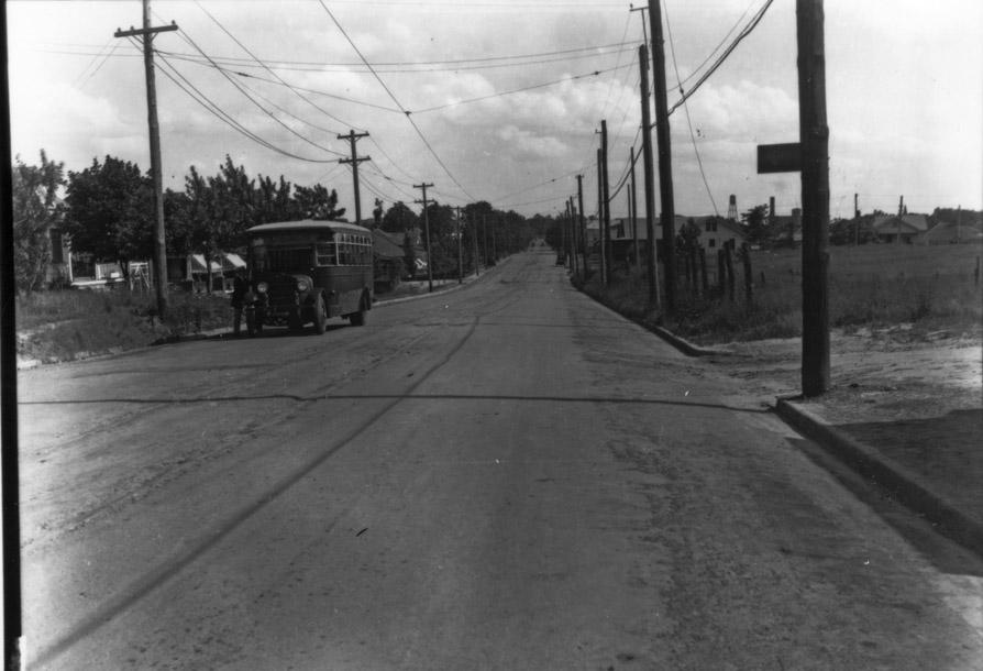
Where is Holloway St. that straight?!?!
Submitted by Amy G. (not verified) on Thu, 10/1/2009 - 1:20pm
There's the Sears water tower in the right background, so this is well out of town. I live out this way and it's pretty straight going out into the county.
Submitted by Dave Piatt (not verified) on Thu, 10/1/2009 - 1:52pm
Near where Holloway and Rochelle would be now?
Submitted by Andrew Sprouse (not verified) on Thu, 10/1/2009 - 2:47pm
Looks like somewhere east of the Durham Cotton Mfg Company -- you can make out the water tower, the smokestack, and the tower on the mill.
http://endangereddurham.blogspot.com/2009/01/durham-cotton-manufacturin…
Submitted by Anonymous (not verified) on Thu, 10/1/2009 - 6:19pm
It's hard to imagine it would be this far out, but could this be east beyond Joyland in the area around what is known as 'turnkey'? Adams Street intersects all the way to the Lynn Road intersection.
I remember Turnkey area being built, but I don't remember there being any sort of factory around that location...of course I'm only 41!
I don't know of anywhere else that Holloway St. is that flat and wide.
Seth Roberts
seth@realtor.com
Submitted by Jerry (not verified) on Thu, 10/1/2009 - 6:48pm
Could this be Joyland looking toward Oak Grove High School ( water tower).
Holloway (98)went slightly down hill here but straight for a few miles .
Submitted by Toby (not verified) on Thu, 10/1/2009 - 7:50pm
@Andrew: based on the way the shadows of the bus and the utility pole are cast from right to left in the photograph, if this is Holloway St the photographer must have been facing to the east. (This far north of the equator, the sun doesn't cast shadows that point south.)
The shape of the land as Holloway goes toward the horizon is fairly distinctive: downhill for a couple hundred yards, then up over a small rise, then up again (maybe a mile away), then it seems to curve to the right. If you search for "2516 holloway st, durham, nc" in google maps, click on street view, and face east, the modern roadway matches up quite nicely with the historic photo. There are some older homes on the left that could match. And finally, if you close streetview, it seems possible that the open field on the right in the historic photo is now the mostly-forested area between S Joyland and S Adams.
Submitted by Gary (not verified) on Thu, 10/1/2009 - 9:14pm
I'm going to hazard a guess of my own, which is a bit different. I'm going to guess Holloway looking west from N. Driver. It's hard for me to believe that Durham would have bus service out to Joyland in the 1920s, or even that that this much infrastructure would be out there then. This could be 1930s, but wouldn't be any later than that based on the bus style. I can't tell if the 'tracks' in the middle of the road are tire ruts or streetcar tracks, but my guess would be that the bus route would still follow the streetcar route at this point, which would have been Holloway to Driver to Angier through East Durham. It also appears that there is an aerial electrical line down the center of the street for the streetcar.
I think the houses visible on the left in the present-day streetview looking west from N. Driver seem to match those in the photo.
The water tower in the distance is problematic; it looks most to me like the water tower of Durham Hosiery Mill No. 6, and I almost think I can see the tower of Mill No. 1 to its right. While things curve a bit strangely out this way, I still have trouble putting them on the right side of the vista. The Durham Cotton Mfg. Co seems even less likely if this is truly Holloway St., as it would be far to the left.
GK
Submitted by Cujo (not verified) on Thu, 10/1/2009 - 11:34pm
I spend a lot of time on Holloway Street! My first thought was in the Joyland area but now I am thinking it is Holloway at Alston Looking east.
Submitted by Toby (not verified) on Fri, 10/2/2009 - 2:27am
@Gary: What about the shadows cast by the utility pole and the bus? Both shadows fall to the left in the picture. The shadow from the pole is perpendicular to the street. If the photographer were facing west (as you propose), then the sun would had to have been angling down from the north.
Regards!
Submitted by Andrew (not verified) on Fri, 10/2/2009 - 3:24am
Toby -- in regards to the shadows, could we be dealing with another reversed negative (similar to the mystery photo of the ice storm)? If that were the case then this could be looking west and have the shadows coming from the correct orientation.
Submitted by Gary (not verified) on Fri, 10/2/2009 - 3:33am
No - it's not reversed. thank goodness for lettering in old pictures
GK
Submitted by Andrew (not verified) on Fri, 10/2/2009 - 3:41am
Ahh, couldn't make out the lettering -- I'm guessing on the bus? Dark computer screen here.
Gary, thanks for doing these!
Submitted by Gary (not verified) on Fri, 10/2/2009 - 11:14am
Toby
You are right - the shadows don't make sense. Andrew, I think you are right - I think that is Durham Cotton Mfg in the background. Scrutinizing it again, the tower looks much more like that than DHM No. 1. Which leads me to think that this is actually a North-South street - that the photo is mis-labeled "Holloway St." based on what the bus says, but that this - ? North Driver, and the bus simply has the route name on it. (Haven't had any time to investigate N. Driver, but based on the streetcar power, bus, and position of DCM, that would fit.) Thoughts?
GK
Submitted by Gary (not verified) on Fri, 10/2/2009 - 3:07pm
Yep, pretty convinced now. Looking south from ~Southgate Street and North Driver. The former, overgrown East Durham Baseball Park is on the right - later the site of East Durham Junior High, later Holton School, now Holton Center.
GK
Submitted by Anonymous (not verified) on Fri, 10/2/2009 - 5:23pm
Gary-
That makes more sense than Holloway. So, this would be late in the day. In your pic, is that marked as a Durham Transit bus, or could it be a Trailways/Greyhound type of bus?
Seth Roberts
seth@realtor.com
Submitted by Gary (not verified) on Fri, 10/2/2009 - 8:01pm
Seth
It isn't marked, but it's typical for a Durham city bus at the time.
GK
Submitted by Anonymous (not verified) on Sun, 10/4/2009 - 12:28am
I agree with Gary about Driver Ave and Southgate. The small shadow on the lower right would be the small building that was Rollins Grocery. It is located at the corner of Driver and Southgate. When I went to East Durham Junior High School in the 50's, the little store was operated by Mrs. Gladys Goggins.
Add new comment
Log in or register to post comments.