Support OpenDurham.org
Preserve Durham's History with a Donation to Open Durham Today!
OpenDurham.org is dedicated to preserving and sharing the rich history of our community. Run by our parent nonprofit, Preservation Durham, the site requires routine maintenance and upgrades. We do not ask for support often (and you can check the box to "hide this message" in the future), but today, we're asking you to chip in with a donation toward annual maintenance of the site. Your support allows us to maintain this valuable resource, expand our archives, and keep the history of Durham accessible to everyone.
Every contribution, big or small, makes a difference and makes you a member of Preservation Durham. Help us keep Durham's history alive for future generations.
Comments
Submitted by Anonymous (not verified) on Thu, 10/8/2009 - 12:16pm
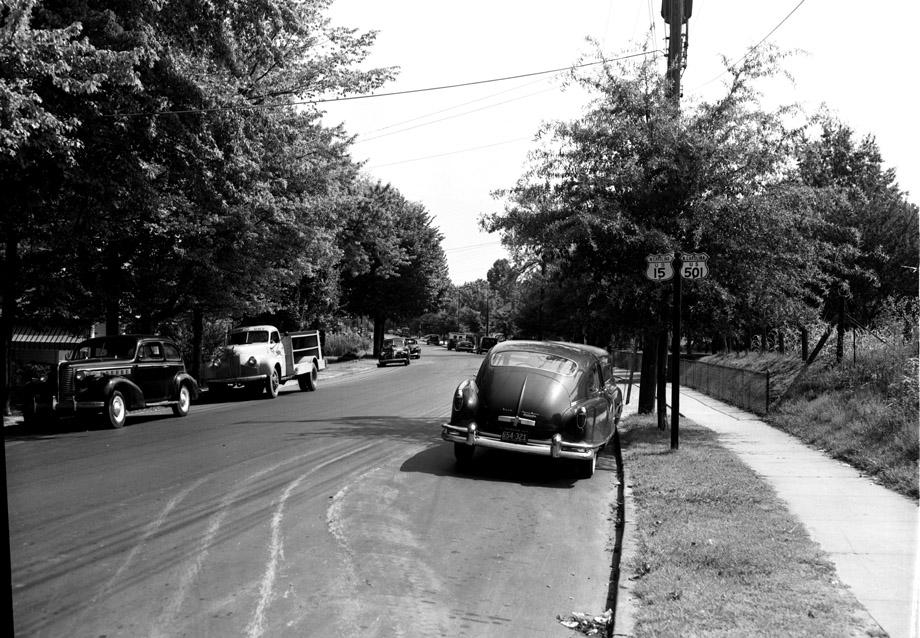
Well, based on the orientation of the car parked on the right, the grooves in the pavement, the configuration of the wires over head and the fence. . . I have no idea. I’m sure this one will be solved soon enough by one of ED’s experts.
Submitted by jplien (not verified) on Thu, 10/8/2009 - 1:24pm
I want this to be University, looking south towards the intersection with Vickers (or maybe Duke?), but I really don't have anything to go on other than the curve of the road.
Submitted by Michael (not verified) on Thu, 10/8/2009 - 1:45pm
Sorry to go off topic....but I found it funny that the cars license plate is 654-321
Submitted by Andrew (not verified) on Thu, 10/8/2009 - 1:56pm
jplien -- the railroad trestle is missing for it to be Univ near Duke/Vickers.
I'm guessing maybe Roxboro looking north, maybe near Canal Street.
Does anyone know when Roxboro & Mangum were switched to one way?
Submitted by X Durh Chik (not verified) on Thu, 10/8/2009 - 2:23pm
I am thinking it looks like the neighborhood near the Cow Store. Remember the convenience store with the cow on top.Think we just called it Old Chapel Hill St. or road.Just turn off to the right onto the new 15 501. There was some real nice houses along there at on time.
For what its worth.
Submitted by Anonymous (not verified) on Thu, 10/8/2009 - 2:29pm
Before the 15-501 by-pass, was 15-501 Roxboro/Mangum? As Andrew mentioned...I don't know when the one way change was made.
I was guessing Roxboro going north in the am or Mangum going south in the pm...knowing which was 15-501 in the early to mid 40's would help.
Michael, I can't see the year on the license plate on my screen. Can you?
Seth Roberts
seth@realtor.com
Submitted by Andrew (not verified) on Thu, 10/8/2009 - 4:15pm
Taking a second look - I think I'm mistaken with the Roxboro & Canal, given that the road goes uphill at that point.
Could it also be somewhere further up Roxboro (north of Club & 85)?
Submitted by Toby (not verified) on Thu, 10/8/2009 - 6:56pm
Just based on the routing of 15-501 in 1950 (approx vintage of the cars), the shadows, the curve of the road, and the shape of the land (banked up on the right side), how 'bout Chapel Hill Rd and Huron St, facing north? I have no idea whether that area would have had much suburban development by then, however.
Submitted by David Jeffreys (not verified) on Thu, 10/8/2009 - 10:20pm
I think 15 and 501 split in downtown Durham with 15 going out Geer St. and 501 going out Roxboro St, so I doubt it would be Roxboro near Club. So it should be somewhere the combined US highways are from central Durham out to the west side toward Chapel Hill. Maybe somewhere out on old Chapel Hill Road. That area was certainly developed out as far as Hope Valley back to the time of the photo.
As to Roxboro and Mangum, I remember they were already one-way in the mid 1950's when I started driving, but don't know how long before that. Again, I think that Roxboro and Mangum would have been US 501, but not US 15.
Submitted by David Jeffreys (not verified) on Thu, 10/8/2009 - 10:32pm
The area was obviously very well developed considering the curbing and sidewalks, so my guess is that it is was along Chapel Hill Road somewhere near the original Maplewood Cemetery (could that be it on the right?) as the road does a lot of curving in that area. The vehicles look like late 40s, early 50s.
Submitted by Woozle (not verified) on Fri, 10/9/2009 - 1:36am
Okay, weighing in because I'm seeing a lot of can't-be-it guesses and nothing that seems likely...
1. From the length of the shadows, it looks like close to noon -- which means the shadows are pointing approximately north, which means that this road is heading south and a bit east, and curves around slightly more to the east as it goes out of sight.
2. Following the present-day path of 15-501 Business, we can eliminate large chunks as either too hilly or not having sidewalks; basically the only stretches it could be (ignoring orientation) are: (a) Roxboro/Mangum (I'm guessing 15-501 went along Roxboro, not Mangum) somewhere south of Markham, and (b) University north of Forestwood/Summit (south/west of that, it gets hilly -- and then after that there would be no sidewalks).
3. The angle is all wrong for any of these stretches, however; that route goes generally southwest, not southeast. It would have to be substantially later in the afternoon for the pictured road to be heading at all west, and I just can't see the shadows being that short at, say, 4pm -- maybe someone experienced at orienteering can judge the likelihood of this?
4. It is, of course, possible that 15-501 business went a substantially different route than it does now, so figuring this out could be key.
Notes on other guesses:
Pretty sure it's not Chapel Hill Rd. near The Cow (now a Mexican food stand which recently got a nod from the New York Times, of all things, iirc); I live right around the corner from there, and although the tone is similar, it doesn't look right.
Can't be Chapel Hill Rd and Huron St; Chapel Hill Rd. goes up a slight hill and is more tightly curved than the picture.
Chapel Hill Road may have been developed out to Hope Valley, but there certainly were not (and still aren't, for the most part) any sidewalks. I don't think it can be near Maplewood Cemetery, either -- reality is too hilly and the picture is too urban for what I'm thinking was there in 1953.
That's a lot of negatives and not much positive, I realize; hope it helps narrow down the hunt, at least.
Submitted by Gary (not verified) on Fri, 10/9/2009 - 2:09am
From what I can tell, 15-501 ran from the bypass (I-85 now) down Roxboro to Lakewood, west on Lakewood to University, west on University to...presumably Chapel Hill Road.
GK
Submitted by Wayne Henderson (not verified) on Fri, 10/9/2009 - 2:34am
I don't know where the photo was taken, but here are some of my resources that may help those more familiar with Durham streets
The license plates are either 1946 or 1948. These are the only years that have the state name and date in that position in yellow on black.
From the web site:http://www.members.cox.net/ncroads/us015.htm
Actual street maps can be found at that address.
Durham: FROM THE SOUTH
Originally, US 15 cut east on Morehead Ave, then Kent St, then east on Chapel Hill St. US 15 turned north on Magnum St, then cut over to US 501 Bus on Markham Ave. US 15 followed US 501 Business north to Geer St, east out of town.
About 1934, US 15 was rerouted to leave Chapel Hill Rd at Foster St which it used north to Geer.
About 1951, US 15 was moved onto the current US 15 Bus-501 Bus routing, with US 15 still using Geer St leaving Roxboro Rd.
In 1956 or 1957, US 15 was rerouted to follow US 501 out to the newly extended US 70 Bypass (current I-85), but cutting west on Geer to Magnum, then north out to US 70. US 15 followed today's I-85/US 15 northeast out of town.
In 1960, US 15 was moved to its current bypass west of Durham, which is shown as complete on the 1957 County Atlas with no number (1959 Official Durham inset also shows unnumbered bypass). This left behind US 15-501 Bus.
Hope this helps - check out the maps.
Wayne Henderson
Submitted by Woozle (not verified) on Fri, 10/9/2009 - 11:38am
Fixed link for US 15
Also, the US 15-501 page has this map of 15-501 in Durham in 1952, which seems key -- it shows, for example, that 15 splits off from 501 at Geer and Mangum heading north -- eliminating a good stretch of possible blocks on Roxboro/Mangum.
Maybe just possibly it's around where Chapel Hill Road crosses what is now 15-501 business (which is more or less what X Durh Chik suggested but I dismissed)?
If it's looking south, the camera would have to be south of McGehee unless McGehee didn't exist yet. I can't tell if there's an intersection behind that electric pole, but if there is it could be Pinecrest Road (where I live) -- I need to walk out there and see if the curve (and the shadows, if I go around noon) match.
That's one of two places where the curve as shown on the map goes in the right direction, the other is (yep) right around The Cow -- I hadn't allowed for the fact that the Boulevard hadn't yet been built.
Submitted by Gary (not verified) on Fri, 10/9/2009 - 11:51am
I don't think Chapel Hill Road through Lakewood was part of 15-501 when this picture was taken. I think the 'event' that warranted this photo for the H-S was the signing of University-Lakewood-Roxboro as 15-501 in 1953 in advance of/concurrently with the bypass construction.
GK
Submitted by Steve (not verified) on Fri, 10/9/2009 - 7:07pm
I would say either Chapel Hill road near Cornwallis or towards the east ends of Morehead or Lakewood Aves.
Submitted by Anonymous (not verified) on Sat, 10/10/2009 - 2:18am
I'm out of guesses on the location. Can anyone read the name on that delivery truck on the left? It appears to have a driver in the seat. I wonder if he was delivering house to house.
Seth Roberts
seth@realtor.com
Submitted by X Durham Chick (not verified) on Sat, 10/10/2009 - 1:38pm
Did anyone notice there are no city tags on the front of the vehicles? What years did this start and stop? Not that it has anything to do with location!Just curious.
Submitted by Jerry (not verified) on Mon, 12/3/2012 - 9:38am
From the memories of my youthful days in Lakewood Park,
this photo is taken on Old Chapel Hill Road. The photographer would have been standing near
the Lakewood Ave. & Old Chapel Hill Road intersection looking towards Palmer Street.
The fence went with the house on the corner of Palmer St. The area on the left side of the
street is now Lakewood Shopping Center.
As a side note, the house on the other corner of Palmer Street was the one used
in the Restoration of the Bennett Place.
Submitted by Jerry (not verified) on Mon, 12/17/2012 - 9:59am
As an addition to my previous comment, 15-501 did run the Old Chapel Hill Road
through Lakewood Park at the time of this photo. I As a young boy I would sit
on the curb in front of our house near old Lakewood School (how smart was that) and pump my arm for
all the truckers to pull the chain to sound their air horn.
I also find the photo interesting because of the "whiteish" lines going around the
parked car. These would have been made by a city street sweeping machine
which the City of Durham operated along all city curb and guttered streets.
Continuing along Old Chapel Hill road, a block further toward town, would
have been Temple Super Market (run by the Broadway brothers) and Ernest
Teague's barber shop on the right. Atwater,s Amoco would have been on the left.
(born 1942 & raised on Old Chapel Hill Rd. in Lakewood Park)
Submitted by Wayne (not verified) on Wed, 2/6/2013 - 8:41am
If you go by Forest Hills and go around the curve to the right before you get to where University and Chapel Hills Blvd split .
Submitted by jerry (not verified) on Wed, 8/21/2013 - 10:15am
Do not understand why this is still a mystery photo.
I am absolutely positive of the locations and descriptions
I have previously submitted.
Add new comment
Log in or register to post comments.