Support OpenDurham.org
Preserve Durham's History with a Donation to Open Durham Today!
OpenDurham.org is dedicated to preserving and sharing the rich history of our community. Run by our parent nonprofit, Preservation Durham, the site requires routine maintenance and upgrades. We do not ask for support often (and you can check the box to "hide this message" in the future), but today, we're asking you to chip in with a donation toward annual maintenance of the site. Your support allows us to maintain this valuable resource, expand our archives, and keep the history of Durham accessible to everyone.
Every contribution, big or small, makes a difference and makes you a member of Preservation Durham. Help us keep Durham's history alive for future generations.
Comments
Submitted by Dave G. (not verified) on Thu, 8/13/2009 - 12:11pm
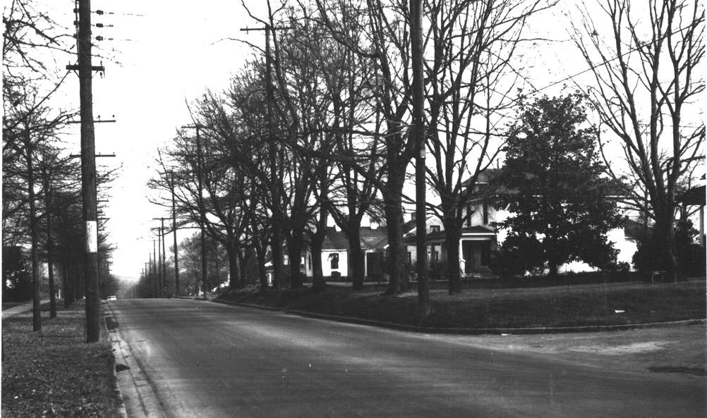
My first reaction was that this was the corner of Vickers and Parker (right at the on-ramp to 147). When I looked at google earth it didn't appear to match-up, though. That bench to the right by the tree either still exists in relatively the same place or it is in another "identified" picture(s) on this site. It's definitely a characteristic I remember seeing before...I just can't remember exactly where right now. Hope this help advance the discussion.
Submitted by Anonymous (not verified) on Thu, 8/13/2009 - 12:58pm
Looks like W. Club Blvd. to me.Only thing is it seems to be going downhill. Then again you may
be right because best I can remember Vickers Ave does sorta go downhill.Goodness gracious alive where do these pictures come from?
My husband and I look forward to these Mysteries.
Submitted by Michael (not verified) on Thu, 8/13/2009 - 1:39pm
Almost looks like Morehead Ave looking towards the ballpark area....
Submitted by Anonymous (not verified) on Thu, 8/13/2009 - 2:22pm
West Club and Norton looking East?
Submitted by a. librarian (not verified) on Thu, 8/13/2009 - 3:29pm
For more mystery photos: http://www.durhamcountylibrary.org/ncc/dhm.php
Submitted by Marsosudiro (not verified) on Thu, 8/13/2009 - 6:31pm
Just spent 30 minutes in Google Street View (aided by the Terrain overlay). No results but it was a lot of fun. Loving the mystery photo thing!
Submitted by Gary (not verified) on Thu, 8/13/2009 - 7:49pm
I think W. Club at Norton, looking east-southeast could be right. It's very hard to tell from Google Streetview because of the screening trees that people have planted, but the houses look like they could fit. I'll need to actually walk it to see - or if someone who knows that block intimately could weigh in, perhaps they can confirm.
GK
Submitted by Minerva (not verified) on Thu, 8/13/2009 - 11:25pm
Another option I like besides Google Maps "Street view" is Bing Maps "Bird's Eye":
Norton and West Club
Submitted by andy (not verified) on Fri, 8/14/2009 - 2:12pm
I concur on West Club and Norton, looking east south east. The house with the small dormer and wrap-around porch is probably 909 W. Club, and you can just see the porch columns of 911 W. Club in the far right of the photo...Roof imagery from googlemaps seems to support this...
Submitted by Anonymous (not verified) on Sun, 8/16/2009 - 12:33am
The house looks exactly like 1411 Green Street at the corner of Berkeley and Green. For this to be the house Berkeley would have had to dead end into Green when the photo was taken. Does anyone know if Berkley dead ended into Green at one point. The granite curbs stop on Berkeley once it crosses over Green and changes to concrete curbs. The addition of sidewalks have take the area where the bench is sitting away and the front of the yard is now a side walk. I think that the closest two Oak trees to the front of the house are still there and the ones that are closer to the road were removed when the side walk was put in. Any thoughts?
Submitted by Tim C. (not verified) on Mon, 8/17/2009 - 12:07am
Like Dave G., I have an uncanny recollection of this place, but I can't find it in StreetView. I also think old S or SW Durham, if I really am remembering a place.
I don't like either of the proffered suggestions, the terrain isn't matching up. The right side is raised up and the left is street level, which is opposite the Norton and Green sites, unless I'm missing your angle (heh heh).
Enjoying the difficult one,
-Tim
Submitted by Anonymous (not verified) on Mon, 8/17/2009 - 11:28am
The house at 1411 Green Street is raised like the photo. The sidewalks that have since been added cut out of the enbankment in the photo and make the street level look flat on GOOGLE street view. The terrain at the Green site matches exactly to photo after you take into account for the sidewalks.
Submitted by Gary (not verified) on Mon, 8/17/2009 - 12:23pm
Hmm. I didn't make it out to look this weekend, but I still think W. Club and Norton is the most probable answer. The piece of the house at the far right edge of the picture, which would sit on the corner of Norton and Green has simple turned columns, like the Cole Couch House on Club; I don't see this on Green St. The north side of the street was likely at grade before Club was widened, and it's a bit hard to tell what the original topography was on the north side pre-Northgate.
GK
Submitted by John Schelp (not verified) on Mon, 8/17/2009 - 12:38pm
> "Does anyone know if Berkley dead ended into Green at one point"...
A 1920 Durham street map shows Berkeley (4th St) continuing past Green (B St) to Markham (A St).
Interestingly, the map shows Markham/A not passing in front of what was to become Asbury Methodist. It stops at Clarendon/6th and picks up again at Sedgefield/5th. (West Durham Methodist moved from Ninth St to Markham/A in 1927 and changed its name to Asbury Methodist in 1944.)
Also, note how Clarendon/6th continues into what is now East Campus -- what was Trinity Park School. Asbury Hall is gone but Bivins Hall, named after the prep school's first headmaster, is still standing. Home of WXDU.
If you stand at Markham and Clarendon today, and look onto East Campus, you can still see Clarendon's old street trees lined up.
Wells & Brinkley Co. 1920 Map of Durham... http://www.owdna.org/1920map.htm
Submitted by John Martin (not verified) on Tue, 8/18/2009 - 1:38am
This is definitely Norton and Club. I used to live nearby and walked along here many, many mornings.
I was fooled a little at first because I couldn't see the Cole-Couch house. But the first full house you can see is the two-story four-square that now has an ugly stockade fence built on top of cement blocks. Beside that is a brick sort-of-ranch house and beside it, a frame sort-of bungalow. All of those are still there.
How much better Club looked when it was two lanes!
Add new comment
Log in or register to post comments.