Support OpenDurham.org
Preserve Durham's History with a Donation to Open Durham Today!
OpenDurham.org is dedicated to preserving and sharing the rich history of our community. Run by our parent nonprofit, Preservation Durham, the site requires routine maintenance and upgrades. We do not ask for support often (and you can check the box to "hide this message" in the future), but today, we're asking you to chip in with a donation toward annual maintenance of the site. Your support allows us to maintain this valuable resource, expand our archives, and keep the history of Durham accessible to everyone.
Every contribution, big or small, makes a difference and makes you a member of Preservation Durham. Help us keep Durham's history alive for future generations.
Comments
Submitted by Andrew Edmonds (not verified) on Thu, 3/4/2010 - 2:07pm
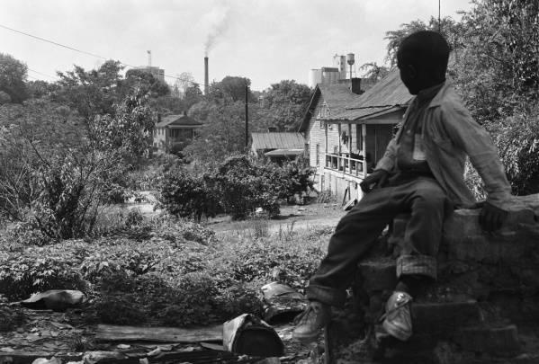
Well, you could ask Billy Barnes, I suppose. Maybe he remembers. The UNC website from which this photo is taken references the railroad tracks, too, not that this is a surprise given the obvious location somewhere near current-day Hillside/St Theresa's.
I feel like that 2-story structure with columns is the key to figuring this out -- but I haven't yet found a building on the Sanborns that seems to face southward and would line up between NC Mutual and ATC.
Submitted by Gary (not verified) on Thu, 3/4/2010 - 2:20pm
Mr. Barnes did not have significant notes re: locations or structures that accompanied his photos, according to my past conversations with the folks at UNC. What information they've provided is what he was able to supply. That's not to say asking again with the photo 'in hand' wouldn't be worth it if anyone out there is up for it.
I'm not so sure that this is as far south as you propose, given the left-to-right configuration of the structures I mentioned, and that Mr. Barnes was facing more westerly, given that you can see the eastern faces of both the AH building and NC Mutual. My general guess would be around the current Rolling Hills area, given the elevation, but I suspect that it may be farther north and east.
GK
Submitted by Marsosudiro (not verified) on Thu, 3/4/2010 - 2:26pm
Awesome. When was the pic taken, more or less?
Submitted by Andrew Edmonds (not verified) on Thu, 3/4/2010 - 2:32pm
Argh, you're right about the east facades. That's pretty clear for the flour mill, now that I bothered to review the photos in your entry for it.
Phil, the UNC site says it was taken May, 1966.
http://dc.lib.unc.edu/cdm4/item_viewer.php?CISOROOT=/barnes&CISOPTR=294…
Submitted by Anonymous (not verified) on Thu, 3/4/2010 - 2:33pm
Myself, I think if you go down E. Main St. to Alston Ave. Turn left go down any of the streets that turn left you will see this picture could have been taken from
between Main St.and Liberty St.Can't recall names of short, hilly streets in that area.
X Durham Chick
Submitted by Andrew Edmonds (not verified) on Thu, 3/4/2010 - 2:57pm
Hey, look at the very next image in the UNC series:
http://dc.lib.unc.edu/cdm4/item_viewer.php?CISOROOT=/barnes&CISOPTR=312…
The location of the Lucky Strike water tower should help to narrow down the compass bearing.
Dang you, Gary, I'm getting no work done this morning!
Submitted by Anonymous (not verified) on Thu, 3/4/2010 - 5:39pm
My guess is either East Piedmont Avenue or East Enterprise Street West of South Roxboro Street looking north.
Submitted by Anonymous (not verified) on Thu, 3/4/2010 - 8:23pm
Could we be looking down upon the future Heritage Square Shopping Center, from about where Fayetteville Street is, just south of 147?? Using Lucky Strike and the American Tobacco Smoke Stack as crosshairs with NCMLB in the middle seems to support this. I think East Piedmont or Enterprise would put the NCMLB out of the "crosshairs" to the right...
Submitted by Anonymous (not verified) on Thu, 3/4/2010 - 8:25pm
Ack. I meant East Piedmont and Enterprise would put the NCMLB out of the crosshairs to the LEFT. I've never shot a gun, sorry.
Submitted by Anonymous (not verified) on Thu, 3/4/2010 - 8:28pm
And finally, the crosshairs I reference are pulled from the 2nd photo Andrew Edmonds links to...
Submitted by Norm (not verified) on Thu, 3/4/2010 - 8:38pm
This is a few blocks North of Holloway St. right around Dowd St.
Submitted by Anonymous (not verified) on Thu, 3/4/2010 - 9:29pm
And if the Heritage Square suggestion holds water, that could be an earlier framed version of St Marks AME Zion at the bottom of the hill??
Submitted by NorfolkBoy (not verified) on Fri, 3/5/2010 - 3:48pm
Being a newcomer to Bull City I have no idea. I just need to say that it is wonderful photograph.
Thank you Gary for this terrific site which has taught me so much of the history of my adopted home town.
Submitted by Norm (not verified) on Sat, 3/6/2010 - 2:42am
Had a slack day today so I drove around the old neighborhood I grew up in, I'm now certain this is right off Hyde Park behind Holloway St. Elementary School,Silos in this are the ones at the old Southern States on Alston Ave.,I now don't believe that the building to left is NCMLT.
Submitted by Toby (not verified) on Sat, 3/6/2010 - 6:30am
Using the other photo from the UNC site, we have four precisely located structures in view -- L to R: Lucky Strike water tower, NC Mutual bldg, Amer Tobacco smokestack, and former Austin-Heaton flour mill.
In addition, the shot had to have been taken from a point on a fairly steep incline, as evidenced by the fact that we are looking down onto nearby rooftops.
By creating four place markers in Google Earth, it is possible to vector toward the only direction from which the photos could have been taken. This is because the NC Mutual building, which is the more distant structure, appears BETWEEN the two American Tobacco structures.
Then, by adding a topo map layer in Google Earth (available here: http://www.gelib.com/maps/_NL/historic-topographic-maps.kml), and searching along that vector for a west-facing hillside not too far away... voila!
I think the photos must have been shot from the vicinity of the current Rick Hendrick Chevrolet dealership building. At the very end of your post on this area (http://endangereddurham.blogspot.com/2008/09/durham-hosiery-mill-no-2-s…), you included an overlay showing where the old streets were compared to the current layout. I would surmise that the shot was taken from a point just south of the intersection of Ramsey and Mt. Vernon Streets. The boy might have been standing on the remains of a house that once faced onto Branch Place, behind the photographer.
Submitted by Norm (not verified) on Sat, 3/6/2010 - 8:01am
I would have to concede that Toby is right, I think it was taken in the area known as the bottoms.
Submitted by Xdurhamchick (not verified) on Sat, 3/6/2010 - 5:41pm
Might try looking at pictures on Gilbert St.
Is that cluster of towers the Farmers Exchange and other businesses in that area?
Submitted by Rick (not verified) on Sat, 3/6/2010 - 8:11pm
I must be looking at the wrong picture. Isn't the Mutual building on the left the smokestack in the middle and the Lucky Strikes tower on the right. In that case I think the picture was taken around Mount Vernon Church or around the front of Whitted School.
Submitted by Rick (not verified) on Sat, 3/6/2010 - 8:44pm
I stand corrected. After seeing the other photo, I didn't see the other water tower. If the water tower to the left is the Lucky Strike Tower there is no way it could have been taken where I originally thought. Thanks so much for these post and all the great replies.
Submitted by Gary (not verified) on Sat, 3/6/2010 - 8:45pm
Toby, I think you are very close, if not spot on. After reviewing some other aerials, I wonder if it is actually from just west of Pine/Roxboro rather than Ramsey, but given the piecemeal demolition that would have taken place by 1966, it is very hard to tell. The orientation of the AH tower and how far to the 'left' the lucky strike smokestack is puts this pretty far north, and there was low, open land between Pine and McMannen (mangum).
For several folks who have mentioned Holloway, Gilbert, etc. - the Austin-Heaton grain tower did resemble the extant Southern States tower, but this is not that area.
GK
Submitted by Rick (not verified) on Sat, 3/6/2010 - 9:22pm
Where would Austin- Heaton Flour Mill be located by todays maps.
Submitted by Gary (not verified) on Sat, 3/6/2010 - 9:29pm
Rick
The Austin-Heaton Mill was located where the Durham Performing Arts Center is now located, at S. Mangum and Vivian.
GK
Submitted by Brad (not verified) on Sun, 3/7/2010 - 1:44am
Toby's got it. For those of you street-viewing at home, here's your line: http://bit.ly/9dgZti
It's the best I could get from Google. The closer on this line you move toward the stadium (and the most likely spot from which the photo was taken), the more you get blocked by the Diamond View building.
Submitted by Ms. M (not verified) on Mon, 3/22/2010 - 3:49pm
Could this possibly be at the top of either South Street or Scout Drive?
Submitted by DELL RAINS (not verified) on Mon, 3/11/2013 - 5:49pm
Being from this nighborhood, I can tell you that this photo was taken on Proctor Street at Meade Pl. looking east. this is near the southeast corner of the lot at that time for John Avery Boys Club. The house that you see the side of down the hill is located on S. Queen St. at Proctor St. The McDonald Family lived in that house
Submitted by DELL RAINS (not verified) on Fri, 3/29/2013 - 4:35pm
correction, this is looking west on proctor street at ramsey street
Add new comment
Log in or register to post comments.