Support OpenDurham.org
Preserve Durham's History with a Donation to Open Durham Today!
OpenDurham.org is dedicated to preserving and sharing the rich history of our community. Run by our parent nonprofit, Preservation Durham, the site requires routine maintenance and upgrades. We do not ask for support often (and you can check the box to "hide this message" in the future), but today, we're asking you to chip in with a donation toward annual maintenance of the site. Your support allows us to maintain this valuable resource, expand our archives, and keep the history of Durham accessible to everyone.
Every contribution, big or small, makes a difference and makes you a member of Preservation Durham. Help us keep Durham's history alive for future generations.
Comments
Submitted by Michael Bacon (not verified) on Fri, 4/9/2010 - 12:21am
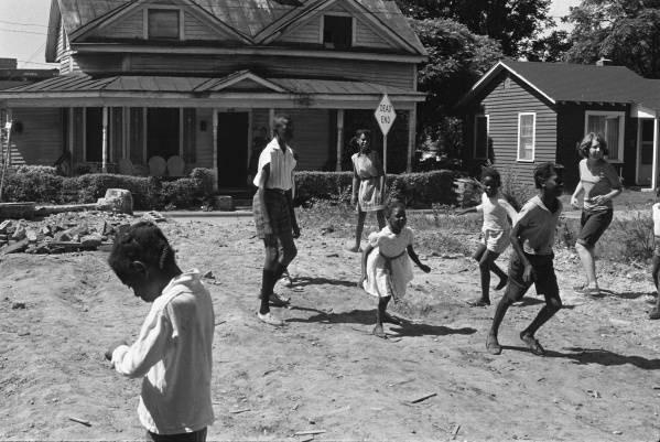
Is there any chance at all that this picture is this building in a former life?
Submitted by Anonymous (not verified) on Fri, 4/9/2010 - 1:31pm
The two front gables seem to be set further apart in the modern picture, and in the historic photo, there is a shadow of what appears to be a chimney in the central part of the roof. The chimney is on the back end of the house in the modern picture. While it's a exceptionally close resemblance, I think they're different. Nice sleuthing though Michael. I suppose the changes could be attributed to renovation work though... but pulling the gables apart seems unrealistic...
Submitted by norahbarnacle (not verified) on Fri, 4/9/2010 - 2:40pm
The dead end sign in front of the house would make no sense for the Chapel Hill Road location...there's no deadendness around there...
Submitted by Michael Bacon (not verified) on Sun, 4/11/2010 - 7:42pm
My thoughts were that the porch and porch roof could have been raised, covering up the point where the gables come together and making them look further apart. The fenestration on the front wall would have had to have been redone as well, as the front door and windows are in different places, but that's not entirely out of the question.
As for the dead end sign, this house sits well back from Chapel Hill St., and has a driveway in front of it that I thought might have been an old dead end dirt road that spurred off from Chapel Hill just southwest of there. The old picture shows the road directly in front of the porch.
Submitted by Gary (not verified) on Sun, 4/11/2010 - 8:28pm
Michael
I don't think so - the gingerbread, rail, etc. on the Chapel Hill Road house is likely original - enough other details are different about the house and landscape that I don't think it's a candidate. Billy Barnes took most of his pictures in Hayti, Edgemont, or Southside/the Bottoms in documenting Operation Breakthrough. My guess would be, based on other photos, that this was somewhere near a community center in one of those areas.
GK
Submitted by Michael Bacon (not verified) on Tue, 4/13/2010 - 6:01pm
In that case, let me propose this instead.
The topology makes me think this is one of Durham's ridgetop roads, and the combination of the kids clothes (wearing shorts and short sleeved shirts) and the length and direction of the shadows make me think this was taken some time in or around the summer, and probably between about 5:30 and 7:30 PM. It's possible it's early morning too (6:30-8:00), but that just seems less likely given the activity.
If it is late in the day, I think the road behind the picture is running somewhere between due north and due east, with right between 30 and 60 degrees being my best guess.
If it's in the Southside area, I'm picking this stretch of Roxboro because I'm guessing that it wasn't part of a continuous street with old Pine St. downtown at some point in the past. If it was the block in the link above, this could have been an old street that ran through the neighborhood behind old Hillside, and this road just dead-ended before it got to Umstead.
In any case, the playground which still stands there was almost certainly there when the picture was taken, as was the rock wall. I hadn't noticed it before, but there easily could be a 2-3 foot drop to the road at the back of the playground the kids are on.
The houses in this shot are clearly 1970's or later. If the original has been demolished, the terrain and slope in this shot would be a reasonable spot.
Submitted by Michael Bacon (not verified) on Fri, 4/16/2010 - 3:09am
Hey, what happened to my comment about the S. Roxboro site?
Submitted by Michael Bacon (not verified) on Fri, 4/16/2010 - 7:27pm
(Ignore that last one -- Gary just hadn't approved the comment for several days. Not trying to be a whiner -- just comes naturally.)
Submitted by Gary (not verified) on Fri, 4/16/2010 - 7:49pm
Sorry Michael - I've had to go to that system to avoid the incessant comment spam, and it's been hard to keep up with of late.
Thanks
GK
Submitted by Michael Bacon (not verified) on Fri, 4/23/2010 - 4:14am
Okay, I can't leave this one alone. The old maps I can find on Digital Durham don't indicate a specific time when Pine/Roxboro was closed there, but it's pretty clear that intersection has been redone many times. I'm feeling more sure about my surmise that this is looking NW across Pine/Roxboro from Hillside Park.
Add new comment
Log in or register to post comments.