Support OpenDurham.org
Preserve Durham's History with a Donation to Open Durham Today!
OpenDurham.org is dedicated to preserving and sharing the rich history of our community. Run by our parent nonprofit, Preservation Durham, the site requires routine maintenance and upgrades. We do not ask for support often (and you can check the box to "hide this message" in the future), but today, we're asking you to chip in with a donation toward annual maintenance of the site. Your support allows us to maintain this valuable resource, expand our archives, and keep the history of Durham accessible to everyone.
Every contribution, big or small, makes a difference and makes you a member of Preservation Durham. Help us keep Durham's history alive for future generations.
Comments
Submitted by skvidal (not verified) on Thu, 5/13/2010 - 2:21pm
I was guessing East Club coming into town - just outside of where the animal shelter is now.
Submitted by skvidal (not verified) on Thu, 5/13/2010 - 2:39pm
That could also be old oxford rd or even hamlin, too - not far outside of the catsburg store.
Submitted by Andrew (not verified) on Thu, 5/13/2010 - 2:40pm
The bungalow on the right seem so familiar.
Two thoughts/observations:
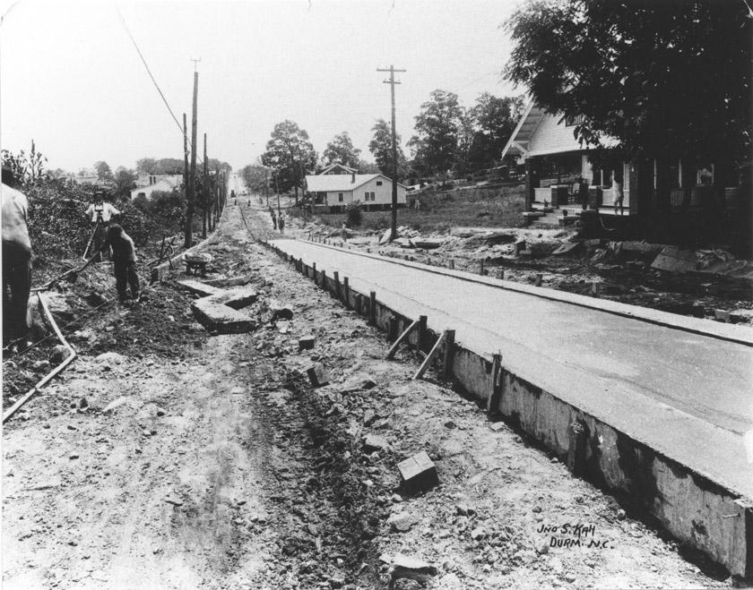
1. Possibly on one of the trolley lines with the paved section to have rails installed later(?)--the reason for this thought is the "mini-curb" approx 2' inside of the framing supports on what I'm assuming is poured concrete. I'm not the familiar with trolley construction but seems like enough of a drop that you could add tracks and then fill up to the grade of the road. Also basing this on the placement of the granite curbs on either side of the street. Based on the houses I'd guess this was taken in the 1920s.
2. Is the person on the porch of the bungalow in shorts/skivvies?
My initial guesses would be W. Club (facing west), W. Chapel Hill below the curve past Anderson (facing SW), or Holloway Street.
Submitted by Paul (not verified) on Thu, 5/13/2010 - 3:09pm
I'd guess Roxboro street, North of downtown towards Old North Durham.
Submitted by Todd T (not verified) on Thu, 5/13/2010 - 5:15pm
Following Andrew's comments, I don't think it is CHRd since there is that significant slope upwards on the right and that doesn't exist anywhere on CHRd.
I agree about the purpose of the massive poured concrete slab being for trolleys. When the city was performing sewer repairs on CHRd between Huron and Anderson the crew came across a 2+ foot concrete slab that they couldn't penetrate. But as far as I know the trolley operated on CHRd only as far as Lakewood. So this picture likewise might be in a place that never had trolley service but might have been a proposed expansion somewhere else other than CHRd.
Submitted by Anonymous (not verified) on Thu, 5/13/2010 - 5:41pm
Gary has thrown us a curve; the caption near the bottom says Durm NC; this photo isn't Durham.
I agree with Andrew; my grandparents lived in the bungalow's twin, constructed between 1920 and 1925.
There is a series of photos of the paving of a stretch of the Durham-Raleigh highway in concrete. One of those photos resembles a portion of Angier Avenue east of East Durham and west of Miami. I don't recall Angier (or Miami) having such hills as we see ahead and to the right, though.
Submitted by Michael Bacon (not verified) on Thu, 5/13/2010 - 9:51pm
The extreme straightness of the road is something which is very rare in Durham. The lack of cross streets makes me think this has to be somewhere out in the country, but the degree to which the houses are established makes me think that this is the re-grading and paving of a considerably older, existing road. There's not much to go on in the shadows, but if anything, it looks more like an east-west road than a north-south road to me.
My guesses are either NC 98 headed out Holloway somehow, or Old NC 10. If I had to pick one, I'd say this spot on Old NC 10, with the first house on the right still standing, and the second one demolished.
Submitted by Anonymous (not verified) on Thu, 5/13/2010 - 11:53pm
What about Club looking west at Buchanan?
lwn
Submitted by aimo (not verified) on Fri, 5/14/2010 - 7:41pm
I immediately thought Angier Ave, looking towards Hwy 70, near where Midway Ave hits. Especially if those are railroad tracks close behind the houses on the right. That would explain why the road was so straight, it followed the tracks.
Submitted by Steve R. (not verified) on Sat, 5/15/2010 - 4:39pm
I would have also said it looks like NC10, just east of the Orange County line (which was paved in the mid or late 1920s at that spot). BUT... here's another photo of Kah's: http://durhamcountylibrary.org/ncc/photo_archives/g/g160.php
A quick Google search shows that John S. Kah was from Florida, and had a studio on West Main Street in Durham by the early 1920s.
Submitted by Steve R (not verified) on Sat, 5/15/2010 - 4:46pm
I would have also said it looks like NC10, just east of the Orange County line (which was paved in the mid or late 1920s at that spot). BUT... here's another photo of Kah's.
Submitted by Andrew (not verified) on Sun, 5/16/2010 - 2:18am
So I was correct in assuming it was paving for trolley tracks!!!
Now just a matter of looking at where the tracks were being expanded c. 1940 (per the date reference on Steve R.'s link).
Submitted by Steve R. (not verified) on Sun, 5/16/2010 - 2:31pm
Although I would be careful with that 1940 date...
I'd speculate it could be anywhere from the mid-1920s up to WWII.
Submitted by Gary (not verified) on Sun, 5/16/2010 - 2:46pm
Definitely not 1940 - many of the dates and more than a few of the captions in the library photo archive are wrong. Streetcar/trolley service in Durham ceased in 1930 - they would not have been expanding service beyond the early 1920s. If this was an expansion vs. a re-laying of tracks, it would most likely be Club Blvd. between Watts Hospital and the reservoir, or along the N. Driver-Holloway route. I found one house along N. Driver that resembles the one on the right in the background, but the rest of the scene doesn't quite seem to fit.
GK
Submitted by Anonymous (not verified) on Mon, 5/17/2010 - 9:46pm
Look at the hill in the extreme distance. The only hill like that I know of in Durham itself would be the Holloway Street bridge over the railroad. This is an artificial rise. The trolley line did come down a long hill on Holloway Street after crossing the railroad bridge into the flat creek bottom beside the Wright Machinery plant and Long Meadow Park.
Submitted by Gary (not verified) on Tue, 5/18/2010 - 12:45pm
Agreed that the topography seems to match Holloway between Railroad and Driver, but I can't place the exact location. The front of the house on the right matches 724 Holloway well, but the houses in the distance don't easily match up. The bungalow style is common enough that it could match with several, since-modified houses along this stretch.
GK
Submitted by Ricky (not verified) on Tue, 5/18/2010 - 9:42pm
The house at 1012 Holloway really looks similar and the topography looks right . Of course as usual there are some differences. But I think I can agree with Gary this is very close.
Submitted by Baraka jones (not verified) on Sun, 5/23/2010 - 8:02pm
Angier Ave straight and narrow
Submitted by Wayne (not verified) on Tue, 2/5/2013 - 7:39am
This looks very much like Holloway/98 past Joyland.
Submitted by Rob Langlois on Sun, 8/22/2021 - 8:44am
It is on the corner of Holloway and Elm st.
Add new comment
Log in or register to post comments.