Support OpenDurham.org
Preserve Durham's History with a Donation to Open Durham Today!
OpenDurham.org is dedicated to preserving and sharing the rich history of our community. Run by our parent nonprofit, Preservation Durham, the site requires routine maintenance and upgrades. We do not ask for support often (and you can check the box to "hide this message" in the future), but today, we're asking you to chip in with a donation toward annual maintenance of the site. Your support allows us to maintain this valuable resource, expand our archives, and keep the history of Durham accessible to everyone.
Every contribution, big or small, makes a difference and makes you a member of Preservation Durham. Help us keep Durham's history alive for future generations.
Comments
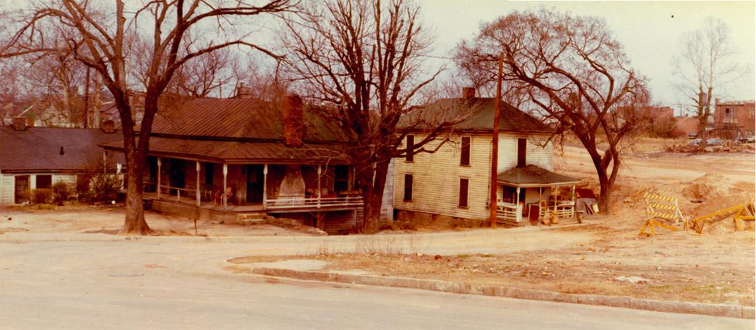
Submitted by Ricky (not verified) on Thu, 5/20/2010 - 2:07pm
Just to get it started . It looks like a water tower in the right background . Could this be an east west expressway photo? Reminds me of the backside of Pettigrew St.
Submitted by Michael Bacon (not verified) on Thu, 5/20/2010 - 2:56pm
It looks to me like Rome Ave., looking across what's to become 147 at the west end of the Smith Warehouse. I'm just assuming that there was a water tower at the East Campus power plant at Maxwell and Campus Dr. at some point.
Submitted by Michael Bacon (not verified) on Thu, 5/20/2010 - 3:08pm
I'll even go further and say the corner house might still be standing. I'm stuck in Chapel Hill, so can't go tooling down Rome St. to check it out, and it looks like Google's Streetview car decided Rome wasn't worth shooting, but based on the overheads, the last house on the north side of Rome sits at an odd angle to the street, and has a roofline consistent with this house, including the wraparound porch.
Submitted by Marsosudiro (not verified) on Thu, 5/20/2010 - 3:20pm
Like everyone else so far, I quickly guessed it might be one of the streets erased by the freeway, or a street just south of it.
I first guessed it might be just west of where Fayetteville crossed 147 (hoping that the buildings in the distance might be 305 South Dillard), then I realized that I would be seeing some railroad tracks, and there aren't any.
Re: Michael Bacon's guess -- Bing's birds eye view (an awesome tool in addition to Google Street View) suggests not. The last house has the shape and angle (good eye, Michael!) but not the roofline or the porch. Also -- if you look across to Maxwell, I think that the mystery photo would have included the big smokestack of the Duke coal plant. So... I think we have to keep looking.
Submitted by jwebster (not verified) on Thu, 5/20/2010 - 3:22pm
The photo appears to be in the same general area as the below from the Billy E. Barnes collection, all showing at least one water tower in them. The collection is concentrated in a poor black downtown neighborhood of the mid 1960's.
http://dc.lib.unc.edu/cdm4/item_viewer.php?CISOROOT=/barnes&CISOPTR=372…
http://dc.lib.unc.edu/cdm4/item_viewer.php?CISOROOT=/barnes&CISOPTR=292…
http://dc.lib.unc.edu/cdm4/item_viewer.php?CISOROOT=/barnes&CISOPTR=312…
http://dc.lib.unc.edu/cdm4/item_viewer.php?CISOROOT=/barnes&CISOPTR=292…
Submitted by Gary (not verified) on Thu, 5/20/2010 - 3:30pm
Don't know if it is in this case, but the water tower that shows up in Hayti pics are usually that of Durham Hosiery Mill No. 6
Submitted by David N. (not verified) on Thu, 5/20/2010 - 5:32pm
Here's my guess: Somewhere around present day Merrick St, looking north-northwest across land cleared for the freeway. The watertower is Durham Hosiery Mill No. 6, and if you squint you can see what may be the smokestack through the tree branches. The brick buildings on the right are the backs of a few remaining businesses fronting on E. Pettigrew St. in the wedge of land northwest of present day Grant St. where the freeway pulls away from the railroad right-of-way.
I've been poking around the site trying to find old arials or Sanborns to check this, but so far no luck.
Submitted by Ricky (not verified) on Thu, 5/20/2010 - 6:29pm
I have done some work recently on a rental house on Rome and I'm pretty sure that house is not still standing. The last house on the left which would be the north side of Rome does not have a wrap around porch.
Submitted by Jenn Carter (not verified) on Thu, 5/20/2010 - 6:32pm
Given how close this looks to the water tower and american tobacco buildings in the background, it seems like this would need to be a bit closer to downtown than Rome or Merrick...
Im wondering if these are houses that once lined the Willard St. area?
Submitted by Gary (not verified) on Thu, 5/20/2010 - 7:36pm
Does not look like Rome Ave. I took a picture of the house Michael is referencing a few years ago
Submitted by David N. (not verified) on Thu, 5/20/2010 - 8:22pm
Take a look here:
http://endangereddurham.blogspot.com/2008/09/526-532-east-pettigrew.html
These were businesses on the south side of E Pettigrew, fronting north. The second photo clearly shows a wide swath cleared behind these buildings. I think the mystery photo may be from residential areas south of this area (and perhaps a bit to the east, behind the 600 or 700 block?) looking north across the cleared land at the backs of some of the remaining commercial buildings on Pettigrew, with the water tower of Durham Hosiery No. 6 rising above them in the background.
Submitted by Gary (not verified) on Thu, 5/20/2010 - 8:57pm
Alright, I'll opine with my best guess for now: 601 and 603 St. Joseph St. - the cleared area in the background is actually the new Fayetteville St., and the commercial buildings are actually the back of the commercial storefronts on Fayetteville St. The building across the cleared area at the right extreme might be the back of this one.
601 and 603 match per the Sanborn maps (particularly looking at the front porch on 601.)
GK
Submitted by David N. (not verified) on Fri, 5/21/2010 - 12:24am
Yep, that commercial building has the same stepped roofline and paired windows. What's more, a line drawn from 601 Joseph to the approximate location of the Mill 6 watertower passes just north of the old intersection of Elm and Fayetteville:
http://tinyurl.com/22rzdph
Submitted by Anonymous (not verified) on Fri, 5/21/2010 - 9:17pm
Your "water tank" in the right rear looks more to me like the top of the feed silos at the Gold Kist chicken processing plant on Alston Ave. Also locally known as the Farmer's Exchange, this place sold bulk chicken feed. This would move the mystery photo location to behind Golden Belt Manufacturing Co.
Submitted by David N. (not verified) on Sat, 5/22/2010 - 3:17pm
Here's the page for the Farmers' Exchange:
http://endangereddurham.blogspot.com/2007/10/john-odaniel-hosiery-mill-…
The silos at the Farmers' Exchange are cylindrical from the ground up and have flat tops. The object in the photo clearly has blue sky beneath a portion of it and appears to me to have a slightly peaked top. Also, apparently by 1970 (around the time of the mystery photo) there were ten silos at the Farmers' Exchange, as well as an even taller rectangular structure, all of which would presumably be visible.
Besides, the location proposed by Gary lines up three locations (601 Joseph, the store at 618 Fayetteville, and the Mill 6 watertower) in a straight line, as they appear in the photo. I'm inclined to believe he has correctly identified the location.
Submitted by Michael Bacon (not verified) on Sat, 5/22/2010 - 7:22pm
Man, I used to be good at this game... :)
Submitted by John Shelton (not verified) on Sun, 5/30/2010 - 3:09am
I strongly feel as though this is the corner of Main and Elizabeth Streets with Commerce Street curving in in the foreground. The brick building to the right is Golden Belt. This intersection has recently been rehabbed for at least the second time since this photo. The Liberty Street/Commerce Street Public Housing resides there as well as the newly bult condos that line the street.
Submitted by Gary (not verified) on Sun, 5/30/2010 - 3:37am
The building on the right is not Golden Belt - the white decorative inlays in the brick are not present on GB. The houses match St. Joseph, and the buildings match Fayetteville (old.) The corner of Main and Elizabeth is visible in this post.
GK
Submitted by Digger (not verified) on Wed, 6/2/2010 - 2:50am
not sure how this works or if the answer has already been revealed but i am pretty sure this is looking west from either Broad St or Iredell St, the vantage looks across the backside of 9th St shops and at the now-scrapped water tower at Erwin Mills. The position of the shooter would be closer to Markham than Perry (much) but hard to say unless the exact spot where the tower was could be pinpointed. The first couple buildings on the right if headed towards Main on Iredell would lead me to believe that these are parcels are where these old houses once were.
I think its closer to the 70s when the phot was taken (at least i hope so).. getting old.
Love the mystery photo game lets play more more
/Diggs
Submitted by DELL RAINS (not verified) on Mon, 3/11/2013 - 5:55pm
Being from the neighborhood, I can tell you that this photo was taken on Proctor St at Ramsay St. The houses are facing Ramsay St. and the buildings to the right are on Pettigrew St. at Ramsay St.
Add new comment
Log in or register to post comments.