Support OpenDurham.org
Preserve Durham's History with a Donation to Open Durham Today!
OpenDurham.org is dedicated to preserving and sharing the rich history of our community. Run by our parent nonprofit, Preservation Durham, the site requires routine maintenance and upgrades. We do not ask for support often (and you can check the box to "hide this message" in the future), but today, we're asking you to chip in with a donation toward annual maintenance of the site. Your support allows us to maintain this valuable resource, expand our archives, and keep the history of Durham accessible to everyone.
Every contribution, big or small, makes a difference and makes you a member of Preservation Durham. Help us keep Durham's history alive for future generations.
Comments
Submitted by Anonymous (not verified) on Tue, 6/22/2010 - 11:05am
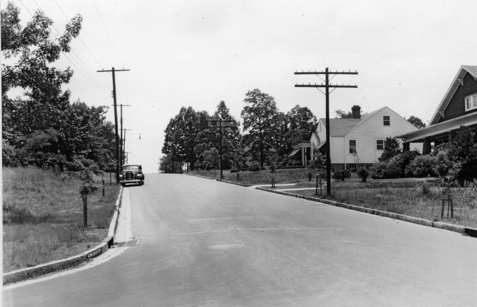
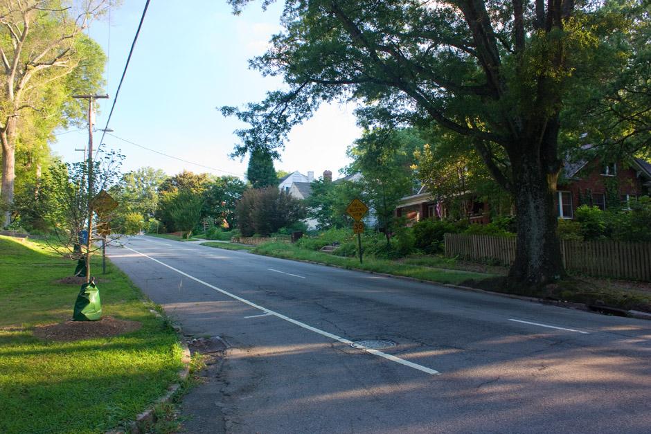
So those are the controversial 70 year old oak trees! Cute little guys.
Submitted by Anonymous (not verified) on Tue, 6/22/2010 - 1:12pm
i think its hilarious to see the little seedling on the right now as a massive oak...yet on the other side, there seem to be the same lil seedlings trying to grow...LOL
TSQ75
Submitted by Michael Bacon (not verified) on Tue, 6/22/2010 - 4:20pm
One wonders if a newspaper ran the first photo with the caption "soon-to-be-buried power lines."
Submitted by Anonymous (not verified) on Tue, 6/22/2010 - 4:28pm
Isn't the car parked facing the wrong direction?
Submitted by Anonymous (not verified) on Tue, 6/22/2010 - 6:57pm
The car isn't facing the wrong directions. It was always a two-way street until later years.
Submitted by Anonymous (not verified) on Tue, 6/22/2010 - 8:56pm
Absolutely fabulous perspective from two different eras of Gregson and Knox!
Obviously it was not a heavily traveled street back in May 1938.
Looks like kids could have played hopscotch in the street back then.
Certainly not the case today!
Impressive picture comparison, love it!
For the anon poster who questioned the car in the wrong direction, well it sure would be nice to have it back to a 2 way street again. Perhaps the road speed demons would be slowed down a bit.
Thanks Gary.
Submitted by Keith Phillips (not verified) on Tue, 6/22/2010 - 8:58pm
Absolutely fabulous perspective from two different eras of Gregson and Knox!
Obviously it was not a heavily traveled street back in May 1938.
Looks like kids could have played hopscotch in the street back then.
Certainly not the case today!
Impressive picture comparison, love it!
For the anon poster who questioned the car in the wrong direction, well it sure would be nice to have it back to a 2 way street again. Perhaps the road speed demons would be slowed down a bit.
Thanks Gary.
Submitted by Steve R. (not verified) on Tue, 6/22/2010 - 9:07pm
Great pics!
The car is parked "old school," with its wheels into the curb on the downhill...
They are indeed cute lil' saplings!
Submitted by Natalie and Harris (not verified) on Wed, 6/23/2010 - 12:26pm
Michael beat me to it.
Submitted by Bryan Gilmer (not verified) on Wed, 6/23/2010 - 1:23pm
Yes, these photos show just how much the massive oaks define Trinity Park for us. Though I understand why redbuds and so forth have been planted beneath power lines, the new trees being planted mostly will not replace the oaks being lost in scale or canopy, in my opinion. Also amazing to see the extent to which that canopy is already lost in the Gregson Street shot.
This is a source of some contemplation for me, as we'll be moving in a couple of weeks from beneath the TP canopy pictured on Duke Street to a newer N. Durham neighborhood where they've planted oak street trees that are now just 15 feet tall or so. Ought to be something in 10 or 20 years.
Submitted by kris (not verified) on Wed, 6/23/2010 - 1:59pm
Google street view shows three additional large trees that surely number among those saplings in 1938. They must have been cut down recently.
Submitted by RWE (not verified) on Wed, 6/23/2010 - 9:13pm
That car is/was parked in front of our house at Gregson and Demerius.
Until fairly recently there were huge oaks along both sides of Gregson. Hurricane Fran took the one at the top of the hill, and the rest followed in sequence over the past 10-12 years.
The three trees on the east side shown in Google Earth were "goalposted" over the years by Duke Energy and were finally taken down earlier this spring and replaced with redbuds.
Submitted by KeepDurhamDifferent! (not verified) on Thu, 6/24/2010 - 2:31pm
Michael Bacon wins the thread.
My mother's neighborhood in Baton Rouge recently voted to bury their power lines. The cost was astounding, and only partly borne by Entergy (local equivalent to Duke Power).
Submitted by Anonymous (not verified) on Thu, 6/24/2010 - 5:59pm
The poles on the right are telephone/telegraph lines. The ones on the left are power poles. If you notice in the later photo, a single black cable runs well beneath the power lines. The poles that were on the right are now gone. That single black cable is now the telephone carrier.
Just FYI. Some folks confuse power lines and telephone lines.
Add new comment
Log in or register to post comments.