Support OpenDurham.org
Preserve Durham's History with a Donation to Open Durham Today!
OpenDurham.org is dedicated to preserving and sharing the rich history of our community. Run by our parent nonprofit, Preservation Durham, the site requires routine maintenance and upgrades. We do not ask for support often (and you can check the box to "hide this message" in the future), but today, we're asking you to chip in with a donation toward annual maintenance of the site. Your support allows us to maintain this valuable resource, expand our archives, and keep the history of Durham accessible to everyone.
Every contribution, big or small, makes a difference and makes you a member of Preservation Durham. Help us keep Durham's history alive for future generations.
Comments
Submitted by Local Durham on Wed, 2/17/2021 - 1:37pm
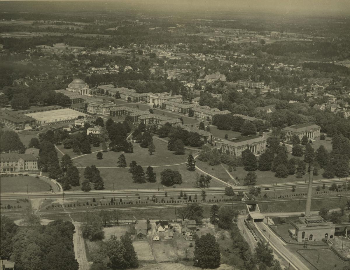
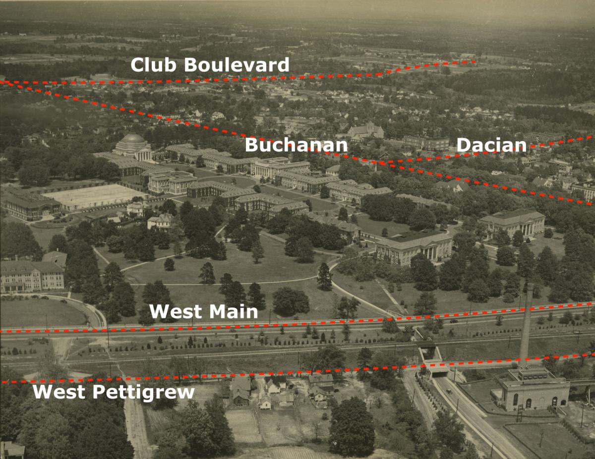
Ok so I downloaded the full res version from the link and studied all of the cars visible (it's what I can relate to). The newest car I can find is heading East on main just passing over the tunnel. It's a 1936 Chevy. Not a 35, and not a 37. The two side windows with the trunk bump give it away. 35 was a totally different design and the 37 had three side windows. You can also make out the shine of the running board trim and front headlamp. I'd also say that most of the cars in front of the Southgate Building are also mid 30's. I believe it's 1935-38
Submitted by DaveG on Thu, 4/1/2021 - 8:56am
It’s extremely difficult to see but the license plate on the front of the car at the curb but what I can make out is very telling to me. I looked at NC license plates for the time period in question - 1930’s. At this time the State issued a new plate every year and the year was stamped into the metal with a contrasting and reflective paint color. They changed the color scheme every year, too. I assume because it would make it very easy for policemen to determine if the plate is current or not. Anyway, looking at the available plates, the apparent color scheme, and where the words are on the plate (this varied from year-to-year, as well) the best option is that this is from 1937. It’s clearly a dark plate (1933 to 1937 are the options in this time period) and with “North Carolina 3?” across the bottom of the plate (only 1935 and 1937 are candidates) in either silver (1935) or yellow (1937) . It seems really unlikely someone would put an old 1935 plate on a new 1936 car...but not out of the question. So, that really only leaves 1937 as the likely answer. There’s always the possibility that they had an old plate on the car and the picture was taken in 1938 or later.
I think there’s a very good possibility that this was taken in the late spring or summer. Most windows are open and there’s even a window A/C visible in one window. These A/C units were developed in the early 1930’s for sale to the public. They were expensive but not anywhere close to as much as the permanently installed versions. Seeing only one there on the building and the rest of the windows being open seems very consistent with pre-WW2 manufacturing/costs for durable goods like these. The price fell dramatically post WW2 as we became more affluent and the entire manufacturing processes improved across the board. If this were after the war I’d expect to see more window A/C’s there.
I completely agree with the post above that the car is a 1937 model. Car manufacturing came to a screeching halt in 1942 and didn’t pick back up until 1946 and really a little later than that in earnest. So, seeing a lot of 1930’s cars in the picture doesn’t necessarily mean it’s the 1930’s as they were just as prevalent throughout WW2 and just after. However, the license plate sure gives a lot of credibility to that notion.
Just to the left of the car is a pile of debris. It doesn’t look to be very sunny at all in the photo. It could be dawn or dusk. I’m absolutely speculating here but maybe there was an awning over the doorway that blew off in a storm and that’s what’s lying there on the sidewalk. It might even be the reason for the photo being taken. I haven’t ever seem an awning on that building in any photo...maybe this is where it made it’s exit, though. Maybe someone could look at newspaper articles and find a story about a big storm during the spring of summer of 1937...or meteorological data, too. If so, you just might could get an exact date. Otherwise, I’m going with spring or summer of 1937.
Add new comment
Log in or register to post comments.